The most celebrated paddle in the south-east of Ireland begins at a thatched fishing village and ends on a private island kingdom. From Kilmore Quay harbour you can see the Saltee Islands on the horizon — a dark outline five kilometres offshore, trailing a white collar of seabirds visible long before any individual bird comes into focus. The crossing takes forty minutes in good conditions. It takes experienced sea kayakers to discover exactly what happens at the wrong state of the tide, when the shallow shingle banks between the islands and the mainland compress the tidal stream into something Irish Times paddlers have compared to a river in spate. That is not a warning to discourage anyone. It is the kind of thing a serious kayaker needs to know before they set out from the slipway.
County Wexford carries more paddling history per kilometre of coastline than almost anywhere else in Ireland. The south coast gave the island its first Viking longships in the 9th century and its first Norman knights in 1169. The sea caves on the Hook Peninsula were used by smugglers for three centuries; in the summer of 1798 two rebel commanders hid in one of them after the rebellion collapsed, before being found and executed on Wexford Bridge. The lighthouse at Hook Head has been guiding ships since the 13th century and is the oldest intact operational lighthouse in the world. All of this is visible, or almost visible, from a kayak on the right route.
The county divides into six distinct paddling zones, from the exposed sea-cliff coastline of Hook Head in the south-west to the sheltered inner estuary at Wexford Harbour in the north-east, with the slow wooded Slaney threading inland to Enniscorthy. This guide covers every zone with the practical detail that makes a trip work: exact launch logistics, tidal windows, operator pricing, difficulty ratings, and the safety information that is unique to this stretch of coast. Wexford is consistently underestimated in favour of Kerry and Donegal, which suits everyone who has already been here.
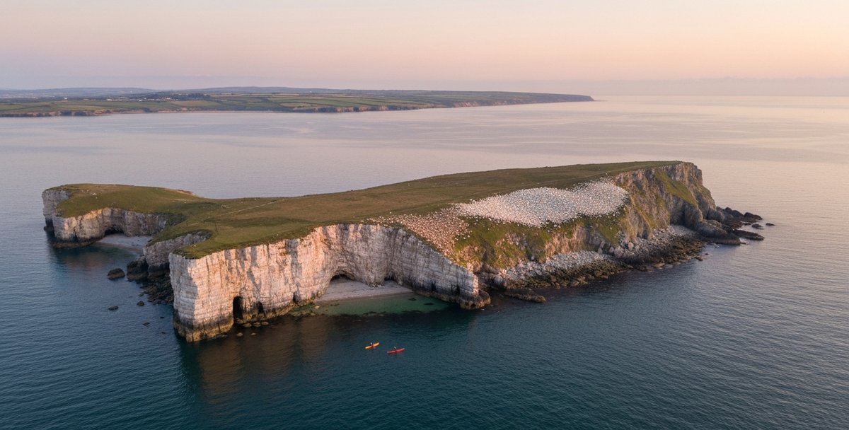
Table of Contents
- The Six Zones at a Glance
- Zone 1 — Kilmore Quay and the Saltee Islands
- Zone 2 — Hook Head Peninsula and Baginbun Bay
- Zone 3 — Bannow Bay and the Norman Coast
- Zone 4 — Wexford Harbour, Raven Point and the Slaney Estuary
- Zone 5 — Curracloe and the North Wexford Coast
- Zone 6 — The River Slaney: Enniscorthy to Wexford
- Wildlife on the Water
- Paddling Clubs
- Getting There
- Tides, Weather and Safety
- Season by Season
- Operators, Hire and Lessons 2026
- Also Read
- Frequently Asked Questions
The Six Zones at a Glance
Wexford’s paddling geography runs roughly clockwise from the south-west coast around to the north-east and then inland up the Slaney.
Zone 1 — Kilmore Quay and the Saltee Islands covers the sea crossing from Kilmore Quay harbour to Great Saltee Island and the paddle around the island’s wildlife cliffs. This is the headline sea kayaking destination in the county.
Zone 2 — Hook Head Peninsula and Baginbun Bay takes in the limestone sea caves, surge channels, and sheltered coves between Fethard-on-Sea and the Hook Head lighthouse — the oldest intact operational lighthouse in the world.
Zone 3 — Bannow Bay and the Norman Coast covers the sheltered tidal inlet where the first Norman fleet landed on 1 May 1169, and the broader dune coast between Bannow Island and Kilmore, including the ruins of Clonmines.
Zone 4 — Wexford Harbour, Raven Point and the Slaney Estuary covers the tidal harbour at Wexford and the sheltered water around Raven Point, where the Slaney meets the sea and the Wexford Wildfowl Reserve holds internationally important bird populations.
Zone 5 — Curracloe and the North Wexford Coast takes in the surf beaches and exposed shore between Raven Point and Cahore, backed by the long dune systems of north Wexford.
Zone 6 — The River Slaney: Enniscorthy to Wexford covers the inland river corridor from Enniscorthy downstream — beginner-friendly, wooded, and quite different from anything on the coast.
| Zone | Difficulty | Tidal Dep. | Beginners OK | Best Season | Operator |
|---|---|---|---|---|---|
| Zone 1 — Kilmore Quay to Saltees | Advanced | High — complex tidal races | No — Level 3–4 only | May–Sep (settled weather) | Self-guided experienced groups |
| Zone 2 — Hook Head & Baginbun Bay | Beginner–Intermediate | Low–Moderate | Yes (guided tours) | Apr–Oct | The Irish Experience — theirishexperience.com |
| Zone 3 — Bannow Bay | Intermediate | Moderate — HW-dep. | Moderate experience | Apr–Oct (neap tides) | Self-guided |
| Zone 4 — Wexford Harbour & Raven Point | Intermediate | High — paddle within 2 hrs of HW | No | May–Sep | Self-guided; Wexford Canoe & Kayak Club |
| Zone 5 — Curracloe & North Wexford | Intermediate–Advanced | Low | Experienced in surf only | Sep–Apr (surf); May–Aug (calmer) | The Surf Shack Ireland — surfshackireland.com |
| Zone 6 — River Slaney, Enniscorthy | Beginner | Low | Yes | Apr–Oct | GoPaddle.ie |
Zone 1 — Kilmore Quay and the Saltee Islands
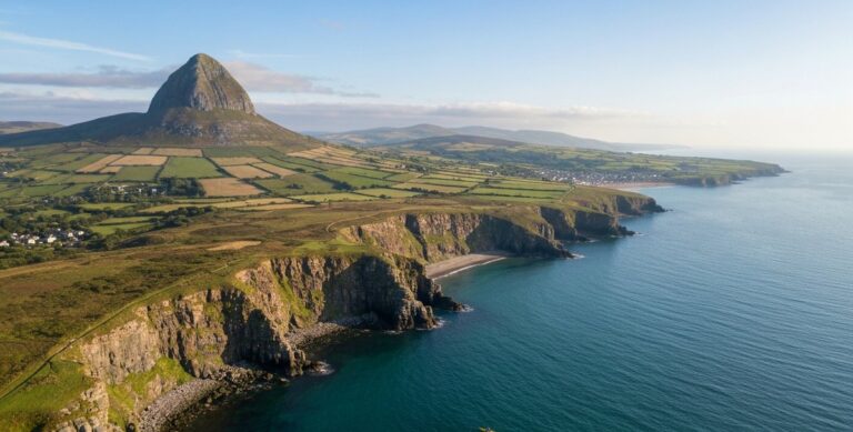
Kilmore Quay is a working fishing village on the south Wexford coast, about 22 kilometres west of Rosslare. The name comes from the Irish Cé na Cille Móire — quay of the big church — and the place still looks the part: whitewashed thatched cottages along the main street, lobster pots on the quayside, an active RNLI station that has operated here since 1847. For a sea kayaker, it is the departure point for the most demanding and rewarding offshore paddle in the county.
The Saltee Islands sit five kilometres south-south-west of the harbour entrance. Great Saltee is 89 hectares of limestone and boulder clay with high cliffs on its western and southern faces and a relatively sheltered cove on the north-west side — the only practical landing spot. Little Saltee, 37 hectares, lies between the mainland and Great Saltee, and is private with no public access. The crossing from Kilmore Quay to the north-west landing beach on Great Saltee is roughly five kilometres as the crow flies; the actual paddle, navigating around the tidal bars, runs closer to six or seven kilometres.
Why the Saltees Crossing Demands Serious Preparation
Two named tidal features on the approach deserve specific attention before you leave the harbour. The first is Sebber Bridge, a shingle bar projecting south from the Kilmore Quay shoreline that narrows Saltee Sound to roughly 600 metres. The second is St Patrick’s Bridge, a longer shingle and rock causeway running north from Little Saltee, marked with seasonal light buoys from April to September. Both generate overfalls at the wrong state of the tide — short, breaking waves caused by tidal current compressing over shallow ground. People who paddle here regularly describe them as resembling a river rapid in miniature. A sea swimmer attempting to cross St Patrick’s Bridge on a poorly timed flood described being pulled over the causeway and then pulled back when trying to return, comparing the force to Couminole in Kerry.
The tidal streams around the Saltees do not follow standard flood-ebb rules, and local paddlers are emphatic that normal tidal prediction methods are unreliable here. Pre-trip research from a dedicated source — the Marine Institute’s tide tables, an Admiralty tidal atlas, or local advice from someone who paddles it regularly — is not optional. The standard timing advice from experienced Irish sea kayakers is to depart roughly two hours before high or low water at Kilmore Quay, when the streams are easing through the sound. Spring tides run hard. The seaward side of both islands faces the open Celtic Sea, and in any swell from the south the south face of Great Saltee produces conditions that paddlers describe as resembling the Atlantic. Force 4 maximum; anything above that and the correct decision is the pub in Kilmore Quay.
No commercial operator currently offers a guided kayak tour to the Saltee Islands. The crossing is done by experienced self-guided groups. If the skill level or conditions are uncertain, the boat ferry from Kilmore Quay (€45 adults, Three Sisters Cruise Company) reaches Great Saltee in twenty minutes.
Great Saltee: Wildlife and History
Great Saltee has been privately owned since 1943, when a Wexford man named Michael Neale purchased the island, shipped a stone throne to the high ground, and declared himself Prince Michael the First of the Saltees. He had made the promise to his mother as a child around 1920. He died in 1998 and the island passed to his family, who still own it. Day visitors are welcome free of charge, typically between 11am and 4:30pm. No camping, no dogs, no overnights. His son became Prince Michael the Second; the throne remains, its inscription specifying that the title can only be claimed by sitting on it in full regalia on the island.
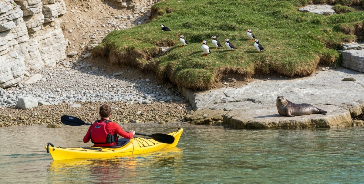
The wildlife is why most paddlers come. Great Saltee holds the guillemot colony closest to Ireland’s largest at approximately 20,000 birds, massed on the western cliffs in late spring and summer. Puffins were nearly eliminated by brown rat predation — the colony fell from over 1,822 pairs at the turn of the century to around 50 pairs by 2018. A €50,000 NPWS rat eradication programme completed in 2020 reversed the collapse: by 2024 over 650 pairs were nesting, and the recovery continues. The best time to see them up close is May and June, when they congregate on the clifftops above their burrows. They depart for the open ocean by late July.
Gannets breed on the south-west face — Great Saltee is Ireland’s second-largest gannetry, after Little Skellig in Kerry. Grey seals haul out on rocks around both islands, with up to 120 animals present in autumn and roughly 20 pups born each year. An ogham stone found on the island in 1925 indicates an early Christian presence. In 1798, the rebel commanders Beauchamp Bagenal Harvey and John Henry Colclough hid in a sea cave on Great Saltee after Wexford fell to the Crown forces. They were found there on 24 June, having been betrayed by a local farmer, and executed on Wexford Bridge four days later. The cave is still there. The cave the tour operator on the Hook Peninsula calls “Hell Hole” — the name of one of four named smuggling caves on Great Saltee — is not a coincidence.
Kilmore Quay Launch Logistics
The slipway at Kilmore Quay harbour is barrier-controlled. A permit is required: €25 per day or €105 for an annual pass valid at Kilmore Quay, Wexford, Courtown, and Cahore. Purchase online in advance at kilmorequaymarina.com. The permit registers your phone number to the barrier system and takes up to five working days to process. Do not arrive expecting to buy a same-day pass — the barrier will not open. Parking for approximately 40 vehicles is available beside the harbour, with overflow in the beach car park behind the harbour wall. The slipway gives tidal access at all hours.
Also keep a sharp lookout for lobster pot gear on the approach south. Kilmore Quay is a working commercial fishing port and the surrounding waters carry a significant density of pots. The ropes are polypropylene — they float — and at the wrong stage of the tide they lie just below the surface in an area you will be paddling through. This is documented in both sailing pilots for the area and in Irish Marine Notice No. 43 of 2021.
Key logistics — Zone 1:
- Launch: Kilmore Quay harbour slipway — permit required in advance, kilmorequaymarina.com — €25/day or €105/year
- Processing time: Up to 5 working days — do not arrive expecting a same-day permit
- Harbour office: 053 912 9955
- Crossing distance: ~5 km to Great Saltee north-west beach; 6–7 km allowing for tidal set
- Difficulty: Advanced — ICU Level 3–4 minimum
- Hazards: Sebber Bridge and St Patrick’s Bridge tidal races; floating lobster pot lines; Force 4 maximum recommended
- RNLI: Kilmore Quay — Tamar-class Killarney, on station since 1847
- Emergency: VHF Ch 16 / 999 or 112 (ask for Coastguard)
Zone 2 — Hook Head Peninsula and Baginbun Bay
The Hook Peninsula is a narrow limestone finger pointing south into St George’s Channel, and its coastline is one of the most dramatic on the south-east coast. The rock here is Devonian limestone and slate, shaped into angular sea caves, surge channels, arches, and slot canyons that fill and drain with each wave. The paddling is as visually rewarding as anything in Wexford.
The lighthouse at Hook Head has been guiding ships into the Barrow estuary since roughly 1210 to 1230, when it was built by William Marshal, Earl of Pembroke — one of the most powerful medieval figures in Europe, guardian of the young King Henry III, and lord of Leinster through his marriage to Strongbow’s daughter. He built the tower to protect merchant shipping calling at his port at New Ross. The current stone tower is the oldest intact operational lighthouse in the world. One qualification is required for that claim to hold: the Tower of Hercules in A Coruña is older, being Roman in origin, but it was heavily reconstructed in 1791. Hook’s medieval fabric is original and the light has been operating since the 13th century. The monks who maintained the beacon fire inside the tower for several centuries were not the builders — William Marshal was — but they kept it burning for three hundred years of pilgrimage, piracy, and passing trade.
Baginbun Bay: Sea Cave Kayaking
The guided sea kayaking in this zone departs from Baginbun Bay, a sheltered cove approximately six kilometres north of the lighthouse near the village of Fethard-on-Sea. The Irish Experience (which also operates as Hook Head Adventures) runs sea cave tours here from April through October. Tours run approximately three hours with around two and a half hours on the water, exploring one of the largest natural sea caves on the Wexford coast, along with arches, slot canyons, and surge pools. Gear is provided. Prices run from approximately €70 per person in a double kayak to €85 in a single; a shorter family version is available for younger children. Minimum age is six in a double with an adult. The same stretch of coastline is where Raymond le Gros landed in 1170 with ten knights and seventy archers, winning a famous battle against a much larger Irish force — a few months before Strongbow himself arrived at Waterford. The operator has named one of its products “Hell Hole Back Kayaking” after one of the four named sea caves on Great Saltee, and the same names run through the smuggling history of both the Saltees and this stretch of the Hook coast.
Independent paddlers with experience can explore the Hook coastline from informal entry points along the peninsula. Fethard-on-Sea has a small beach and slipway; Slade Harbour, a tiny working harbour near the lighthouse, is used as an informal put-in. Duncannon, on the Waterford Harbour side of the peninsula, is more sheltered and well suited to moderate paddlers wanting estuary water rather than open-sea conditions. The tidal race known as Tower Race forms off Hook Head when the Waterford Harbour ebb conflicts with the coastal stream; in strong westerly winds it extends up to two nautical miles east of the lighthouse, and navigating around it rather than through it is the standard advice.
Key logistics — Zone 2:
- Guided launch: Baginbun Bay, Fethard-on-Sea — book at theirishexperience.com
- Independent launch options: Fethard-on-Sea beach; Slade Harbour; Duncannon (sheltered estuary, north Hook)
- Difficulty: Beginner with guide; Intermediate independent (sea conditions variable)
- Season: April–October (guided tours); year-round for experienced independent paddlers
- Operator: The Irish Experience / Hook Head Adventures — theirishexperience.com — from €70 per person
- Hook Head Lighthouse visitor centre: Open daily 09:30–17:00 (to 18:00 June–August), adult €10
Zone 3 — Bannow Bay and the Norman Coast
Bannow Bay requires patience. The bay faces south between the dune headlands of Bannow Island and Ballyteigue Burrow, and at high water it holds a wide, sheltered stretch of tidal water with nothing much to disturb it. At low water springs the sand and mud spread across most of the bay and it empties to a thin channel along the western edge. Tidal range at springs is 3.3 metres. The paddling window is the two to three hours either side of high water on neap tides.
The history here runs deep enough to affect how the place feels when you are on the water. On 1 May 1169, three ships from Wales beached on the strand at Bannow Bay carrying Robert fitz Stephen, roughly sixty mailed knights, and three hundred archers. It was the first Norman landing in Ireland and it changed the country permanently. Strongbow is the name that became famous, but he arrived in August 1170 at Waterford; Robert fitz Stephen landed here, fourteen months earlier. Raymond le Gros and his force arrived that same summer at Baginbun Head, the promontory that shelters the kayak launch site in Zone 2.
The medieval town of Bannow stood on what is now Bannow Island, a peninsula formed by the silting of the original island’s tidal channels. It was a Norman borough with six or nine named streets, a market square, a castle, and a 200-metre quay. The Black Death struck in 1348; the harbour silted progressively as sand accumulated in the bay; trade moved to New Ross; and by the 17th century the streets were buried. What remains is the roofless nave of St Mary’s Church on the headland — standing by 1200, visible from the water. The town was buried by sand, not drowned by rising sea; the distinction matters and competitors often get it wrong.
Clonmines, on the western shore of the bay, is similarly abandoned. Established by William Marshal — the same man who built Hook Head lighthouse — in the early 13th century, it functioned as a port and borough until the bay became too silted for navigation in the 17th century. Two tower houses, an Augustinian priory, and the parish church of St Nicholas survive and are visible from the water, making it the finest deserted medieval borough accessible by kayak anywhere in Ireland. The bay and its surrounding dunes are also a designated SAC (IE0000697) protecting eleven wetland and dune habitats, and an SPA for Light-bellied Brent Geese and wading birds in winter.
Ballyteigue Burrow, the dune system on the eastern side of the bay, is an NPWS Nature Reserve and a Ramsar Wetland of International Importance (designated 1987). It holds the largest wild asparagus population in Ireland, a lichen found nowhere else in the country, and a Little Tern nesting colony at the western end that NPWS protects with temporary fencing from May through August. Kayakers landing on the beach inside the nesting zone during those months would be in breach of wildlife protection legislation.
Key logistics — Zone 3:
- Launch: Bannow village area — informal shoreline access; no formal slipway confirmed; contact Wexford Harbour office for current advice
- Paddling window: Within 2–3 hours of high water on neap tides (3.3 m spring range; bay almost dries at MLWS)
- Difficulty: Intermediate (tidal, no nearby commercial rescue cover)
- Season: April–October
- Wildlife: Light-bellied Brent Geese and waders in winter; terns at Ballyteigue Burrow May–Aug
- Do not land: Ballyteigue Burrow beach at the tern nesting site, May–August
Zone 4 — Wexford Harbour, Raven Point and the Slaney Estuary
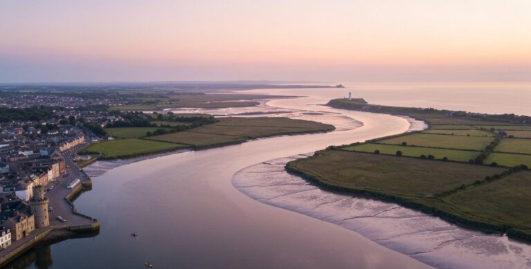
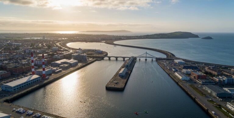
Wexford Harbour takes its name from the Old Norse Veisafjordr — inlet of the mudflats — and the name is accurate today as it was in the 9th century when Norse settlers built the first wooden fortifications at the mouth of the Slaney. The harbour is a tidal mudflat estuary that becomes an accessible and rewarding paddle near high water and becomes an impassable plain of mud at low water springs. The tidal range at springs is 1.5 metres at Wexford town; Mean Low Water Springs puts the main navigation channel at 0.5 metres above chart datum. The spring tidal streams in the channel run at up to 2 knots. Most of the harbour outside the dredged channel dries. The harbour authority’s own navigation notes describe the seabed as “an ever-shifting scenario” of moving sand and mud. This is not a venue where you arrive without having checked the tides.
The practical paddling window is two hours either side of high water. The approach to the harbour from the sea is dangerous in winds between south-east and north-east, when seas break on the bar at the entrance. These conditions arrive with more frequency and less warning on this coast than they would seem to on a fine morning in Wexford town.
Raven Point: Little Terns and the Wildfowl Reserve
The Raven Point is the forested sand spit at the northern entrance to Wexford Harbour, where the Slaney meets the sea. It is a National Nature Reserve (established 1983), a Special Area of Conservation (IE0000710), and a Ramsar Wetland (designated 31 July 1986). The Corsican pine woodland covering most of the spit was planted from the 1930s onward to stabilise the dunes and protect the North Slob farmland from blown sand. Red Squirrels live in the woods; Crossbills breed here, which is unusual in an Irish context.
At the southern tip of the spit, a Little Tern colony nests each summer. Little Terns are among Ireland’s rarest breeding seabirds, and The Raven holds one of the country’s surviving colonies. NPWS fences the nesting area from May through August. A kayaker landing on the Raven Point beach inside the fenced area during those months would be disturbing active nesting habitat under the Wildlife Act 1976. The practical guidance is simple: do not land there between May and August.
On the harbour side of the spit, behind the dunes, the sheltered inner water is calm and flat regardless of conditions outside. This is the paddling character of the inner harbour: quiet, wildlife-rich, good for a slow paddle in settled weather.
The Wexford Wildfowl Reserve and the Slobs
The North Slob, the flat polder land immediately behind the sea wall north of the spit, was reclaimed from the bay in the 1840s in a famine relief scheme. The resulting land sits below sea level and is drained by pumps — it is a genuine polder, directly comparable in engineering terms to the Dutch examples that inspired it. This is the core of the Wexford Wildfowl Reserve, jointly managed by NPWS and BirdWatch Ireland, and Ramsar-designated since 1984.
The Greenland White-fronted Goose is the reserve’s headline species and the conservation numbers are striking. The global population stood at approximately 15,000 birds in spring 2024 — the lowest since coordinated counts began in 1982, down 57.8% from the 1999 peak. Of those 15,000 birds, roughly 4,283 spent the winter of 2023/24 at Wexford, representing approximately 35% of the entire world population on a single site. Paddling the sheltered water behind Raven Point on a calm October morning with geese overhead is one of the more unusual wildlife experiences available on the south-east coast.
Launch logistics — Zone 4: The formal slipway for Wexford Harbour is on the Ferrybank side of the Slaney. Same permit scheme as Kilmore Quay: €25/day or €105/year, purchased online with up to five working days’ advance notice; barrier phone 087 737 9689.
Key logistics — Zone 4:
- Launch: Ferrybank slipway, Wexford — permit required in advance at wexfordharbour.com, €25/day; barrier 087 737 9689
- Paddling window: Within 2 hours of HW; spring streams 2 knots in channel
- Difficulty: Intermediate (tidal, shifting sands)
- Season: May–September (bar approach dangerous in SE–NE winds)
- Wildlife: Greenland White-fronted Geese Oct–Apr; Little Terns May–Aug (do not land at Raven Point during nesting)
Zone 5 — Curracloe and the North Wexford Coast
Curracloe is not a flatwater paddling venue. The beach faces directly east across the Irish Sea and draws consistent swell from Atlantic low-pressure systems that curve around the south of Ireland into the Celtic Sea. It has produced reliable surf for decades, and in June and July 1997 it became internationally famous when Steven Spielberg filmed the Omaha Beach landing sequence of Saving Private Ryan at the Ballinesker section of the strand, using 1,500 extras and $12 million in production budget over fifteen shooting days. The dunes and the sandy profile matched the terrain closely enough. The beach was fully restored afterward.
For an experienced sea kayaker, Curracloe and the fourteen kilometres of coast north to Cahore offer surf launching practice, exposed coast touring in settled high-pressure conditions, and winter paddling that keeps skills current. The Surf Shack Ireland operates surf and watersport sessions from Curracloe, including kayaking, March through October. The beach facilities building has showers, changing rooms, and lockers. Three access points serve the beach — Ballinesker, White Gap, and Culleton’s Gap — and the White Gap area operates with lifeguard supervision in summer. Beach launching is free; maintain separation from the lifeguarded swimming area.
Cahore Point, 35 kilometres north of Wexford Town, has a working fishing slipway at Cahore Pier that provides a practical put-in for the exposed rocky coast around the headland. No guided kayaking operates here. The geology is Corsican granite — coarse, angular, and distinctly different from the limestone and slate of the south coast.
Key logistics — Zone 5:
- Launch: Curracloe beach (Ballinesker, White Gap, Culleton’s Gap; no permit); Cahore Pier (fishing slipway)
- Difficulty: Intermediate–Advanced (surf launching, exposed coast)
- Season: Sep–Apr for surf conditions; May–Aug for calmer open-water
- Operator: The Surf Shack Ireland — surfshackireland.com — March–October
Zone 6 — The River Slaney: Enniscorthy to Wexford
The Slaney rises in the Wicklow Mountains and flows south for approximately 120 kilometres before meeting tidal water just below Enniscorthy, roughly 29 kilometres upriver from the sea. The tidal influence is felt all the way to the town — high water at Enniscorthy lags approximately one and a half hours behind high water at Wexford Harbour, and the transition at the town bridge from a swift, clear, shallow river to a slow, deep tidal corridor is described by those who know it as remarkably abrupt.
GoPaddle, run by Susan Doyle from a base at Edermine Bridge between Enniscorthy and Wexford, is the county’s main structured provider for river kayaking. Their guided Slaney tour covers four kilometres downstream in roughly two hours, from Edermine heading north toward Enniscorthy passing the ruins of Browns Castle (destroyed by Cromwell in 1649 and left as a shell ever since), then branching up the smaller Boro River through broadleaf woodland. All gear is included; tours cost from €39 per person; minimum age for a solo kayak is twelve, with doubles available from age six. GoPaddle runs Tuesday to Sunday from approximately April through October, closed November to January.
Paddlers wanting a longer independent trip can follow the full tidal corridor from Enniscorthy to Ferrycarrig, roughly twenty kilometres of increasingly wide estuary taking around three hours at a comfortable pace. The river widens significantly south of Enniscorthy and becomes exposed to wind across the open water — this is the primary hazard the East Coast Sea Kayaking Club flag when they discuss the route. The shifting sandbanks near the harbour approach, known as the Patches and marked with five IWAI-placed channel buoys, are the main navigational complication at low water. Grey seals appear at high tide as far upstream as the Edermine stretch.
There is no Slaney Blueway. The river is not part of the Waterways Ireland Blueways network, which is centred on the Shannon, Shannon-Erne, and Barrow systems. The Barrow Blueway is the nearest designated trail, running through County Carlow — see our Blueways Ireland guide for the full picture.
Key logistics — Zone 6:
- Guided launch: Edermine Bridge, near Enniscorthy (GoPaddle.ie)
- Independent put-in: Slipway near the Riverside Hotel, Enniscorthy
- Difficulty: Beginner (guided, upper section); Intermediate (full Enniscorthy–Wexford tidal run)
- Season: April–October (GoPaddle closed November–January)
- Operator: GoPaddle.ie — from €39/person, guided 2-hour tour — +353 86 390 5642
Wildlife on the Water
The wildlife case for a Wexford paddle differs by zone but is excellent across several of them. The summary below covers the main encounters by location and season.
Saltee Islands: Seabirds, Seals, and Occasional Sharks
Great Saltee’s wildlife statistics are not modest. The guillemot colony on the western cliffs is approximately 20,000 birds — among Ireland’s largest. Razorbills share the ledges. Gannets breed on the south-west face in Ireland’s second-largest gannetry, after Little Skellig in Kerry. Manx Shearwaters nest in burrows and are almost entirely nocturnal at the colony — rarely seen in daylight, though familiar to anyone who has paddled around the island at dusk. The puffin recovery from 50 pairs in 2018 to over 650 pairs in 2024, following the rat eradication programme, is one of the more encouraging conservation stories in recent Irish wildlife. May and June are the peak months. Total: more than 20 breeding seabird species; over 220 species recorded annually.
Grey seals are resident. Up to 120 animals haul out around both islands in autumn, producing roughly 20 pups between August and December on rocks away from the main tourist landing. On the water approach from Kilmore Quay a paddler will typically pass within close range of individuals hauled out on the tidal rocks, and will often attract curious animals from the water.
In March 2022 a survey documented an aggregation of approximately 100 to 150 basking sharks roughly six to eight miles south-west of Hook Head — one of the largest aggregations ever recorded by the Irish Whale and Dolphin Group. Basking sharks appear in the south Wexford waters in late spring and summer, following plankton blooms. They are filter feeders, entirely non-aggressive, and a kayak encounter with one is an unusual piece of luck. Harbour porpoise are the most commonly seen cetacean on this coast. Common dolphins, Risso’s dolphins, and bottlenose dolphins are all recorded in the wider area.
Wexford Harbour: The Geese
The winter spectacle at Wexford Harbour has a different character from the Saltee experience — quieter, dependent on scale and timing rather than proximity to a cliff face. The Greenland White-fronted Goose flocks that use the Slobs as a wintering site are, in conservation terms, among the most important wildlife congregations in the country. These birds breed on the west Greenland tundra and cross the North Atlantic to winter at a handful of sites in Ireland and Britain; Wexford holds roughly a third of the global population and the population is declining. Bewick’s Swans, once more than 100 animals at Wexford, have been reduced to around 20 individuals as milder winters shorten their migration. Over 250 bird species in total have been recorded across the harbour and slob system, including 29 duck species and 42 wader species.
Paddling Clubs in County Wexford
Wexford Canoe and Kayak Club is the only dedicated paddling club physically based in the county. It operates from Wexford Town with the River Slaney as its primary water, running trips every second Sunday, plus occasional visits to rivers in Carlow and Wicklow. Around 20 members; described as a mobile roof-rack club with no fixed base. Contact via allakaulina.wordpress.com.
GoPaddle at Edermine is a Canoeing Ireland Registered Provider and the practical first option for structured instruction or beginner courses in the county.
East Coast Sea Kayaking Club (ecskc.eu) is Dublin-based but runs regular trips to the Saltees and Wexford coastal waters, accepting new members from anywhere on the east coast. It is the appropriate organisation for paddlers who want to extend from the guided experience into independent sea kayaking.
Getting There
County Wexford is approximately 140 kilometres from Dublin by road, around one hour fifty minutes on the M11/N11. Kilmore Quay is a further 22 kilometres south-west of Wexford Town on the R739 and R736. Hook Head is reached via New Ross and the R733 or via Waterford and the R773. There is no rail link to the southern parts of the county where most of the kayaking is centred.
By ferry, Rosslare Europort receives services from Stena Line (Fishguard), Irish Ferries (Pembroke, Cherbourg, Roscoff), Brittany Ferries (Cherbourg, Bilbao), and DFDS Seaways (Dunkirk). The port operates approximately six to eight large vessel movements per day. Kayakers arriving from Wales or France should note that the port has no recreational craft facilities and the waters immediately around it are a genuine hazard for small craft. The tidal stream at the pierhead runs south for nine hours of the tidal cycle, reaching up to four knots at Low Water Springs, and the ferry departure tracks cut close to the East Breakwater. VHF Channel 12 is Rosslare Harbour Operations. The correct approach is to stage from Rosslare Strand beach, north of the port.
Tides, Weather and Safety
Tidal Planning
Tidal conditions vary sharply across the six zones. Kilmore Quay has a spring range of 3.2 metres (MHWS 3.8 m, MLWS 0.6 m), and the offshore streams around the Saltees are complex and require specific research. Hook Head produces its own tidal race — Tower Race — when the Waterford Harbour ebb is stronger than the west-going coastal stream; in strong westerly winds it extends up to two nautical miles east of the lighthouse and is described in Irish sailing pilots as “violent.” Carnsore Point, the south-east corner of the island, produces a race of its own at up to 2.5 knots. All of these features are navigable with good tidal planning; none is safely improvised.
Rosslare has an anomalously small tidal range for this stretch of coast — around 1.6 metres at springs — because the tidal waves from the Irish Sea and the Atlantic partially cancel at St George’s Channel. The Admiralty publication NP256 (Tidal Stream Atlas: Irish Sea and Bristol Channel) is the authoritative reference for the full area.
Inside Wexford Harbour, the simpler rule applies: paddle within two hours of high water, plan your direction around the 2-knot spring stream in the channel, and do not venture onto the mudflats away from the dredged route.
| Force | Wind (knots) | Sea state | Wexford advice |
|---|---|---|---|
| F0–F2 | 0–6 | Glass-flat | All zones open — Slaney, Bannow Bay, Wexford Harbour, Hook guided tours |
| F3 | 7–10 | Light ripples | Sheltered zones fine. Experienced paddlers only at Kilmore Quay and Curracloe |
| F4 | 11–16 | Moderate waves | Maximum for Saltees crossing. Hook Tower Race extends 2 nm east. Beginners off open coast |
| F5 | 17–21 | Rough | Saltees crossing unsafe. Wexford bar approach dangerous. River Slaney only workable zone |
| F6+ | 22+ | Very rough — no paddle | Kilmore Quay RNLI on standby. Tower Race and Carnsore Race active. All coastal zones off |
Weather
The Met Éireann coastal forecast zone covering Wexford is South Irish Sea, running from Howth Head to Valentia. VHF weather broadcasts are available from the Rosslare remote site on working Channel 05 (updated following the 2021 Coast Guard radio upgrade). VHF Channel 16 remains the primary distress and calling channel, monitored at all times.
The south Wexford coast is exposed to winds from the south and east. Swell from the south-east builds on the approach to the Saltees and the Hook Head coast without significant offshore obstruction. The standard guidance applies here with particular force: Force 4 is workable for experienced paddlers on this coast; Force 5 is decision-making territory; Force 6 is not a paddling day.
Safety Contacts
MRCC Dublin is the Marine Rescue Co-ordination Centre responsible for the entire Wexford coast — its area runs from Carlingford Lough in the north down to Ballycotton in County Cork. This surprises some paddlers who assume Malin Head covers the island; it does not cover anything south of Clifden in County Galway. MRCC Dublin phone: +353 1 662 0922.
Kilmore Quay RNLI — Tamar-class Killarney (on station since 1847) — covers the south Wexford coast and the waters around the Saltee Islands; the station has responded to multiple Saltee-area incidents.
Rosslare Harbour RNLI — Severn-class Donald and Barbara Broadhead (on station since 2004) — covers the south-east coast and approaches to St George’s Channel.
In any maritime emergency: VHF Channel 16, or call 999/112 and ask for the Coastguard.
Season by Season
January to March — The Greenland White-fronted Geese are still at Wexford, making the harbour zone the most rewarding winter paddle in the county. The south coast is an expert-only environment in winter swell, and inexperienced paddlers have no business on it.
April to May — The best opening conditions of the year. The Saltees become realistic from late April as settled high-pressure periods lengthen. Puffins return to Great Saltee late April; May is the first peak month. Hook Peninsula guided tours begin. GoPaddle opens on the Slaney. The geese have departed.
June to August — Peak season across the county. Saltee puffins at their best in June; seal families on the rocks by July. The Hook Peninsula guided tours are busy on good weekends. Curracloe is at its calmest for open-water touring. Basking sharks are possible off Hook Head.
September to October — Grey seal pup season begins on the Saltees, with the highest haul-out numbers by mid-October. Autumn bird migration through the islands and harbour. White-fronted Geese begin returning to the Slobs in October. The south coast swell builds.
November to December — The Wildfowl Reserve is at its best for waterfowl. The south coast is for experienced paddlers only. GoPaddle closes by November.
Operators, Hire and Lessons — 2026
Guided Tours
The Irish Experience / Hook Head Adventures Sea cave kayaking on the Hook Peninsula, departing from Baginbun Beach near Fethard-on-Sea. The main tour runs approximately three hours and covers sea caves, cliff arches, and surge channels. Guides add Norman landing history and smuggling lore from the caves that share names with those on Great Saltee. A shorter family version and a sunset tour are also available. All gear included.
- Location: Fethard-on-Sea, Hook Peninsula (Y34 P778)
- Website: theirishexperience.com
- Price: From €70/person (double kayak); from €85/person (single kayak)
- Season: April–October
- Min age: 6 (double with adult)
GoPaddle.ie Guided river kayaking on the River Slaney near Enniscorthy. Two-hour, four-kilometre downstream tour through a designated Special Area of Conservation, all gear and wetsuit included, Canoeing Ireland-qualified guides. Also runs beginners’ courses, children’s camps, and private instruction.
- Location: Near Edermine Bridge, Enniscorthy
- Website: gopaddle.ie
- Price: From €39/person
- Season: April–October (Tuesday to Sunday)
- Phone: +353 86 390 5642
Hire and Lessons
Rosslare Watersports Centre Kayaking lessons and hire at Rosslare Strand, primarily July and August. Sessions-based. No public pricing.
- Facebook: facebook.com/rosslarewatersports | Phone: 085 161 6900
The Surf Shack Ireland Surf school with kayaking sessions at Curracloe, Rosslare, and Bannow. March to October. Kayaking is a secondary activity alongside surfing and SUP — contact for current availability.
- Website: surfshackireland.com
Harbour Slipway Permit Summary
Four Wexford harbours share one permit scheme. Buy online in advance — up to five working days required for barrier registration. Day-of purchase will not open any barrier.
| Operator | Activity | Price | Season |
|---|---|---|---|
| GoPaddle | Guided river tour, River Slaney | from €39/person | Apr–Oct |
| The Irish Experience | Hook sea cave tour — double kayak | from €70/person | Apr–Oct |
| The Irish Experience | Hook sea cave tour — single kayak | from €85/person | Apr–Oct |
| Three Sisters | Saltee Islands passenger ferry (reference) | €45 adult | Apr–Oct |
| Rosslare Watersports | Kayak hire and lessons | contact for price | Jul–Aug |
| Launch | Barrier phone | Day rate | Annual |
|---|---|---|---|
| Kilmore Quay | Harbour office 053 912 9955 | €25 | €105 |
| Wexford (Ferrybank) | 087 737 9689 | €25 | €105 |
| Courtown | 085 241 8919 | €25 | €105 |
| Cahore | Posted on sign | €25 | €105 |
Buy at kilmorequaymarina.com or wexfordharbour.com.
Also Read
- Sea Kayaking Ireland — Complete Guide — national overview, conditions, gear and planning for Irish coastal paddling
- Kayaking Waterford — Harbour, Tramore, Dunmore East and the Copper Coast — the paddling ground directly west of Wexford, sharing the Hook Head coastline
- Kayaking Wicklow — Bray Head to Arklow and Lough Tay — the coast north of Wexford, from Arklow to Bray
- Kayak Rental Ireland — 54 Verified Operators by County — national hire directory with Wexford entries
- Kayaking Clubs in Ireland — 45 Verified Clubs by County — full club listing including Wexford Canoe and Kayak Club
- Blueways Ireland — Every Paddling Trail Mapped — includes the Barrow Blueway, connecting to Wexford waters at New Ross
Frequently Asked Questions
Is kayaking to the Saltee Islands suitable for beginners? No. The Kilmore Quay to Great Saltee crossing is rated ICU Level 3–4 and is appropriate only for experienced sea kayakers with tidal water training. Tidal races at Sebber Bridge and St Patrick’s Bridge create conditions compared by those who have been caught in them to a river in spate. Beginners should take a guided tour on the Hook Peninsula with The Irish Experience, or book onto GoPaddle’s River Slaney tour.
When is the best time to see puffins on the Saltee Islands? May and June are the peak months. Puffins arrive on Great Saltee from late April, reach their highest numbers around burrows in May and June, and begin departing in late July. The puffin colony has been recovering strongly since the rat eradication programme completed in 2020, with over 650 pairs estimated in 2024 compared to around 50 in 2018.
Do you need a permit to launch a kayak at Kilmore Quay? Yes. The slipway at Kilmore Quay harbour is barrier-controlled and requires a permit purchased online in advance at kilmorequaymarina.com. The permit costs €25 per day or €105 annually (valid at Kilmore Quay, Wexford, Courtown, and Cahore). Processing takes up to five working days — same-day purchase will not open the barrier.
Is there a guided kayak tour to the Saltee Islands? No commercial operator currently runs a dedicated guided kayak trip to the Saltees. The crossing requires Level 3–4 sea kayaking ability and detailed tidal knowledge, and is done by self-sufficient experienced groups. If you want to visit the islands without that level of experience, the Three Sisters passenger ferry from Kilmore Quay costs €45 (adults) and takes twenty minutes.
Is Wexford Harbour good for kayaking? Within a tidal window, yes. Wexford Harbour is an enclosed tidal estuary that becomes accessible and rewarding near high water, when the channel fills and the inner harbour is calm. At low water springs most of the harbour dries to exposed mud. Paddle within two hours of high water, plan your direction around the 2-knot spring current, and stay in the marked channel. Not a beginner venue.
What do I need to know about kayaking near Rosslare Europort? The ferry lanes at Rosslare Europort carry six to eight large vessel movements per day to Wales, France, and Belgium. The tidal stream at the pierhead runs south at up to four knots for nine hours of the cycle. Kayakers should avoid the main approach channel and ferry lanes entirely, staging from Rosslare Strand beach to the north. If crossing near the port is unavoidable, call Harbour Operations on VHF Channel 12 before approach.
Which Coast Guard centre covers County Wexford? MRCC Dublin covers the entire east and south-east coast from Carlingford Lough down to Ballycotton, County Cork. Malin Head MRSC covers only the north-west, from Clifden to Lough Foyle. In any maritime emergency, call VHF Channel 16 or dial 999/112 and ask for the Coastguard.
Planning Your Trip — Summary
Beginners should book with GoPaddle on the River Slaney (€39, all gear, April–October, Enniscorthy area) or with The Irish Experience on the Hook Peninsula (€70 guided sea cave tour, April–October). Both offer full instruction in appropriate conditions.
Intermediate paddlers will find Bannow Bay and Wexford Harbour rewarding. Both need tidal planning: Bannow is accessible only near high water with a 3.3-metre spring range; Wexford Harbour has a 2-knot spring stream and dries at low water. Neither has commercial rescue cover nearby, so carry VHF and appropriate safety kit.
Advanced paddlers come to Wexford for the Saltees. Pre-purchase your Kilmore Quay slipway permit five working days in advance. Research the tidal gates at Sebber Bridge and St Patrick’s Bridge from a dedicated source before you arrive. Pick a day with a settled forecast and light winds, ideally neap tides. The crossing and the island together are as good as anything available on the east coast of Ireland, and the cave names — Hell Hole, Happy Hole, Otter’s Cave, Lady Walker’s Cave — have been earning their keep for three hundred years.
No comments yet on this route.
Be the first to share your experience — conditions, access, hazards, or anything a future paddler should know.
Login to join the discussion