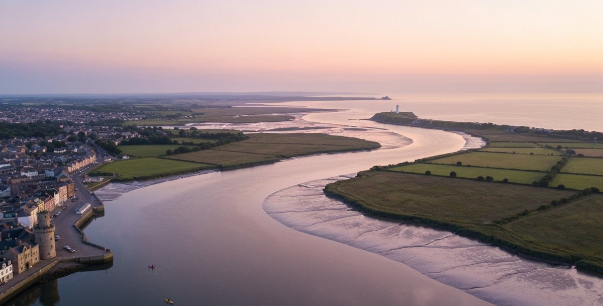
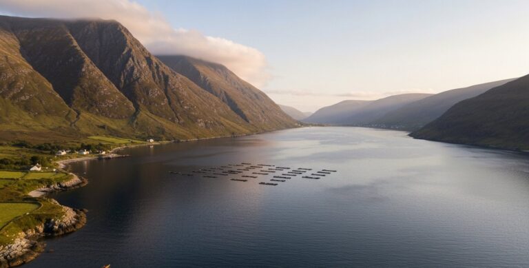
There is a moment, roughly twenty minutes into an ebb-tide paddle from Cheekpoint, when Waterford Harbour stops feeling like a river and starts feeling like the sea. The water broadens, the wind finds angles that were blocked by the bankside hedges upstream, and Hook Head appears in the distance — a white lighthouse tower on a long limestone peninsula, one of the oldest structures of its kind in Europe. Behind you, the Suir, Barrow and Nore have been sliding together for several kilometres through a wide green valley, and ahead lies open tidal water that eventually washes the cliffs of the Copper Coast, the fishing village of Dunmore East, and the exposed sweep of Tramore Bay. This is the largest paddling estuary in the south-east of Ireland, and it is dramatically underrated.
Waterford is conventionally dated to 914 AD, when Norse settlers re-established a permanent foothold at Port Lairge after earlier raiding activity in the area stretching back to at least 856 AD. Those Vikings chose this location because the Three Sisters — the Suir, Barrow and Nore — created a deep, sheltered anchorage accessible from the sea, wide enough for longships, tidal enough to launch and land on a schedule. More than eleven hundred years later, the harbour those settlers chose is still one of the most interesting paddling environments in the country. The tidal Suir carries spring currents of up to 3.5 knots past Waterford’s medieval quays. Cheekpoint sits at the sequential confluence where the Barrow-Nore flow joins the Suir. And downstream, beyond the commercial port at Belview, the estuary opens into a harbour framed on the east by Hook Head and the Waterford coast.
This guide covers everything you need to plan a kayaking trip to County Waterford in 2026. We have divided the county into five paddling zones, from the city estuary downstream to the full length of the Copper Coast UNESCO Global Geopark. Whether you are a Dublin day-tripper looking for a weekend destination, a visiting paddler wanting to combine sea kayaking with Viking heritage, or a local who has been meaning to properly explore the backstrand at Tramore, this is the reference you need.
The Five Zones at a Glance
Waterford’s paddling geography divides naturally along the coastline and up the river systems that feed the harbour. The zones below move roughly west to east along the coast and then inland up the Suir.
Zone 1 — Waterford City Estuary and the Suir Corridor runs from Waterford City quays downstream to Cheekpoint, approximately 8 km of tidal river with the city’s Viking walls visible from the water.
Zone 2 — Cheekpoint and the Three Sisters Confluence covers the broader estuary around Cheekpoint village, where the harbour properly begins and where commercial shipping traffic requires awareness.
Zone 3 — Dunmore East and the East Coast takes in the sheltered harbour at Dunmore East, the cove kayaking around the cliffs, and the approaches to Hook Head.
Zone 4 — Tramore Bay and the Backstrand covers the large tidal bay at Tramore, its well-known surf beach and the sheltered tidal lagoon behind the dunes.
Zone 5 — The Copper Coast and the Waterford Geopark runs the full stretch of dramatic cliffs, sea stacks, sea arches and boulder beaches from Tramore westward to Dungarvan, through the heart of the UNESCO Global Geopark.
An optional inland extension covers the River Suir above the city — the freshwater and upper tidal corridor running upstream toward Carrick-on-Suir for paddlers who prefer river touring over open-water paddling.
| Zone | Difficulty | Tidal Dep. | Beginners OK | Best Season | Operator |
|---|---|---|---|---|---|
| Zone 1 — City Estuary (quays → Cheekpoint, 8 km) | Intermediate | High — spring ebb to 3.5 kn | No | Apr–Oct (neap tides only) | Waterford Kayak Club; self-guided |
| Zone 2 — Cheekpoint & Three Sisters | Advanced | Very High — commercial shipping 24/7 | No | May–Sep (neap only) | Experienced club members only |
| Zone 3 — Dunmore East | Beginner–Intermediate | Moderate | Yes (guided tours) | Apr–Oct | Dunmore Adventure Centre — dunmoreadventure.ie |
| Zone 4 — Tramore Bay & Backstrand | Beginner | Moderate | Yes — Tramore Pier only | Year-round (Backstrand: HW neap only) | Tramore Kayak Club |
| Zone 5 — Copper Coast Geopark | Intermediate–Advanced | Low–Moderate | Yes (guided only) | Jun–Oct best | Pure Adventure Tramore — pureadventure.ie — €45–65 pp |
Zone 1 — Waterford City Estuary and the Suir Corridor
The River Suir is tidal all the way to Carrick-on-Suir, roughly 27 km upstream of Waterford City. That means Waterford City sits not at the limit of tidal influence but in the middle of a long tidal reach, with the ebb and flow affecting water levels, current direction and paddling conditions throughout the urban stretch. Spring tidal range at Waterford is approximately 4 metres, with ebb currents alongside the quays reaching 3.5 knots. This is not a lazy urban river paddle. On a spring ebb, the Suir through Waterford city carries enough flow to complicate ferry-glide crossings and push a loaded sea kayak downstream at a pace that demands planning.
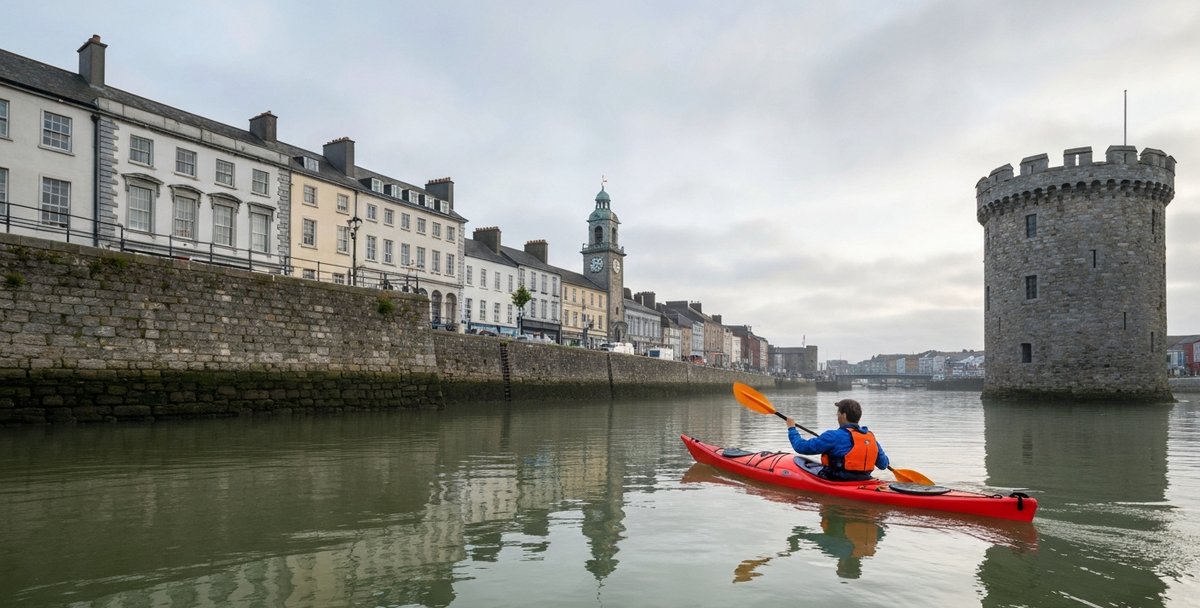
The standard access point for Waterford City paddlers is the Boat Club slip at the western end of the quays, off Merchants Quay. There is limited roadside parking nearby, but a larger car park is available on the north side of the river at the Rice Bridge end. The quays themselves are active — small commercial craft use the eastern section, and there are vessel movements associated with the city marina — so launching should be done promptly and kayaks should hug the edges of the channel while moving through the built-up section. The most rewarding stretch begins once you clear the city centre and the river bends south-east past the Ard Rí and Grattan Quay areas, where the bankside architecture gives way to reed beds and open mudflats.
Reginald’s Tower, which stands at the eastern end of the Waterford quays, is visible from the water and worth pausing to appreciate. The current stone structure was built between approximately 1253 and 1280 and is Ireland’s oldest civic building, having been in continuous civic use since a Viking wooden tower occupied the same site after 914 AD. Seeing it from a kayak — low on the water, looking up at a circular Norman tower above a tidal river — gives a more arresting sense of the city’s age than any museum display. The city walls extend inland from the tower, and the waterfront remains one of the most intact stretches of medieval riverside streetscape in Ireland.
A downstream float from the city to Cheekpoint on an ebb tide takes roughly two to two and a half hours, covering about 8 km. The pace is largely dictated by the current: on a big spring ebb you are moving fast and need to plan your exit carefully. Cheekpoint village has a pier and slipway that serves as the typical takeout point, but parking is limited in the village itself. Most kayakers doing this stretch arrange a shuttle or time their paddle to coincide with high water so they can reverse the route on the flood. Paddling the flood tide upstream from Cheekpoint to Waterford city is equally straightforward and gives you a very different perspective on the same scenery, the current carrying you towards the city rather than away from it.
The banks of the Suir between Waterford and Cheekpoint are designated as part of the Lower River Suir SAC (Special Area of Conservation), with extensive mudflat and reed bed habitats supporting curlew, redshank, little egret and kingfisher. In winter the mudflats host significant numbers of wading birds, and even in summer the birding is excellent compared to most Irish rivers of this length.
Key logistics — Zone 1:
- Launch: Boat Club slip, Merchants Quay, Waterford City (free, tidal access)
- Takeout: Cheekpoint Pier (limited village parking; roadside layby 400m from pier)
- Distance: ~8 km one way
- Tide dependency: High — paddle the ebb downstream, the flood upstream; avoid spring ebb in open boats
- Difficulty: Intermediate (tidal currents, shipping awareness required)
- Parking: City car parks within 800m of launch; Cheekpoint has minimal parking
Zone 2 — Cheekpoint and the Three Sisters Confluence
Cheekpoint is one of those small Irish villages that is completely unremarkable on land and extraordinary on the water. It sits at the south bank of the Suir, roughly where the river’s valley opens into the broader harbour, and from the pier you can look across to the mouth of the Barrow — or rather, to the combined Barrow-Nore, since the River Nore joins the River Barrow near New Ross, some 17 km to the north, and the two arrive at Cheekpoint already merged. This sequential double confluence — Nore into Barrow first, then Barrow-Nore into the Suir at Cheekpoint — is what the Irish tradition calls the Three Sisters: Cumar na dTrí Uisce, the confluence of the three waters. Waterford Harbour begins here.
The paddling logic around Cheekpoint is more complex than anywhere else in this guide. Three tidal rivers are converging, commercial vessels are navigating the main channel to and from Belview Port (the primary cargo facility for the Port of Waterford, handling around 810 vessels and 2.5 million tonnes of cargo annually), and the currents interact in ways that are not immediately predictable from a reading of a single tide table. The main shipping channel lies to the south of Cheekpoint and is clearly buoyed. Kayakers should understand the channel layout before paddling this section: give large vessels a very wide berth, treat moving ships as absolute priority, and avoid positioning yourself in a channel where a ship cannot deviate.
That said, away from the shipping lane, the waters around Cheekpoint are superb. The north bank of the Suir, across from the village, is accessible by paddling across the river at slack water, and the waterway that runs behind Little Island (the Barrow channel) offers a more sheltered alternative to the main estuary. The ferry crossing at Passage East, a few kilometres downstream on the south bank, is a landmark of the lower harbour — a vehicle ferry runs between Passage East on the Waterford side and Ballyhack in County Wexford, and its crossing line is marked on maritime charts. Kayakers should cross well away from the ferry’s line when it is operating.
The estuary at and below Cheekpoint is broad, typically 600–900 metres wide, and the water feels distinctly different to a river — saltier, choppier in any wind above Force 3, and with a swell component on exposed days that is entirely absent upstream. For sea kayakers, this transition zone is where Waterford’s paddling character fully reveals itself. For open-water and recreational paddlers in short boats, this is also where conditions can exceed safe limits rapidly. The fetch from the south-east — the same direction as the harbour mouth — means that a south-easterly wind piling into the estuary creates steep short chop that can swamp a sit-on-top or an inflatable. Check wind direction before committing to the lower estuary.
Key logistics — Zone 2:
- Access: Cheekpoint Pier (limited parking in village); Passage East ferry slip on the south bank
- Difficulty: Intermediate to Advanced (shipping traffic, open estuary conditions, complex currents)
- Notable feature: Three Sisters confluence — Suir, Barrow and Nore
- Commercial shipping: Active at all hours. Belview Port operates 24/7. Main channel is south of Cheekpoint; always give vessels absolute right of way
- Tidal reference: Waterford Port tidal predictions (Irish Tidal Tables, ukho.gov.uk, tideschart.com)
Zone 3 — Dunmore East and the East Waterford Coast
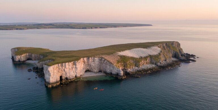
Dunmore East is the kind of place that should be better known to paddlers than it is. It sits at the southern tip of the Waterford coastline, facing directly onto the Celtic Sea, with a working fishing harbour on one side and a series of red sandstone cliffs stretching north along the bay. Our Dunmore East paddling route page has full tidal stream data and launch details for the area. The village itself is immediately appealing — coloured thatched cottages above the harbour, a good pub, a proper seafood restaurant at the pier — and the kayaking off the cliff faces is varied enough to occupy two or three days.
The harbour at Dunmore East is used by a commercial fishing fleet, and launches from the pier require awareness of vessel movements. Dunmore Adventure Centre, located at the harbour, offers kayaking experiences that include guided exploration of the coves and smaller inlets along the bay. The sea caves in the area — including Rathmoylan Cave, which some sources describe as one of Ireland’s longer sea caves at roughly 60 metres — are primarily accessed by land at low tide via the cliff walk. They are not reliably part of a standard kayak-from-the-harbour route, and no operator currently lists them as a standard guided kayak destination. What the harbour-launched tours do offer is access to the smaller cove-inlets along the cliff faces north of the village, which are genuinely rewarding and require only modest sea conditions to explore safely.
The coastline running south from Dunmore East toward Hook Head is exposed and serious. The cliffs here are red Old Red Sandstone, dropping directly into the sea, with no beach landings for several kilometres. This section is only appropriate for competent sea kayakers with proper open-water kit and someone in the group who understands tidal streams and potential landing difficulties in an emergency. The reward is commensurately impressive: the cliffs are dramatic, the water is clear and takes the colour of the underlying red stone, and seabirds — guillemot, razorbill, fulmar, kittiwake — nest in the crevices above you.
Hook Head itself deserves separate mention. The lighthouse at Hook Head dates to approximately 1210-1240 AD, making it the oldest intact operational lighthouse of medieval construction in the world. (The Tower of Hercules in A Coruña, built in the first century AD, holds the broader title of oldest operational lighthouse overall — a fact that promotional materials for Hook Head sometimes elide.) Paddling out to Hook Head from Dunmore East is a serious undertaking — the distance is roughly 8 km one way, the headland generates significant tidal races and overfalls in certain conditions, and the approach from the south can funnel swells in a way that makes the immediate vicinity of the lighthouse base hazardous. Those with the skills and experience to make the crossing are rewarded with extraordinary scenery and, on a clear day, views back across the full width of Waterford Harbour to the Copper Coast cliffs.
For paddlers at the intermediate level, the waters between Dunmore East harbour and Swines Head, roughly 4 km to the north, offer excellent day-trip content. The cliff faces along this stretch have several accessible cove inlets, a stack or two, and enough geometric variety in the rock architecture to keep things visually interesting. Conditions depend heavily on wind direction: a southerly or south-easterly fetch makes the exposed cliff faces rough and the coves uncomfortable; a northerly or westerly wind leaves the same stretch in a lee and produces flat water against dramatic cliffs. Given that Dunmore East faces broadly east, the best paddling conditions are typically found in light westerlies or northerlies.
Operators — Zone 3:
- Dunmore Adventure Centre: Guided kayak tours from Dunmore East harbour; suitable for beginners and families; cove exploration focus. Check current pricing directly with the operator.
- Several Waterford and south-east based sea kayak guides operate bespoke tours to the Hook Head area; these are typically arranged through Canoeing Ireland’s instructor directory.
Key logistics — Zone 3:
- Launch: Dunmore East harbour slipway (check with harbour master for access; fishing fleet has priority)
- Parking: Village car park above harbour; additional overflow parking on main approach road
- Difficulty: Beginner/intermediate for harbour and north bay; advanced for full cliff traverses and Hook Head approaches
- Exposed fetch: South-east; best conditions in northerly or westerly winds
- Nearest rescue: Dunmore East RNLI Lifeboat Station is on the pier
Zone 4 — Tramore Bay and the Backstrand
Tramore is Waterford’s most popular seaside resort, a town of around 10,000 people sitting behind a 5-km sweep of Atlantic beach. The beach itself — exposed, surf-rolled, facing due south into the Celtic Sea — is not a kayak venue. But behind the beach, separated from the open Atlantic by a barrier of dunes and a sand spit, lies the Backstrand: a large tidal lagoon of approximately 500 hectares that fills and drains with each tide cycle through the narrow Rinnashark channel at the eastern end of the spit.
The Backstrand is ecologically extraordinary. It holds SAC (Special Area of Conservation) designation as a lagoon habitat, SPA (Special Protection Area) status for its wintering wildfowl populations, and is a Ramsar site — a wetland of international importance. In autumn and winter it holds thousands of waders and wildfowl: brent geese, wigeon, golden plover, lapwing, curlew, dunlin. The visual contrast between the exposed surf beach on one side of the dune barrier and the flat, bird-rich lagoon on the other is one of the more striking environmental experiences Waterford offers.
For kayakers, the Backstrand requires careful handling and realistic expectations. At high tide — particularly around springs, when the lagoon fills to a greater extent — the Backstrand offers sheltered, flat water behind the dunes, largely protected from the south-westerly winds that dominate the Irish coastal climate. This can be genuinely calmer water than anything available on the open beach. However, describing it simply as a beginner venue would be misleading. The tidal dynamics inside the Backstrand are more extreme than a glance at a map suggests. At low tide, the lagoon drains to near-empty: 500 hectares of sand and mud are exposed, leaving very little navigable water. A paddler caught inside on a falling tide in a sit-on-top kayak, without local knowledge and without watching the clock, can find themselves sitting on mud a long way from the launch point. The Rinnashark channel at the entrance generates strong currents on spring tides — conditions that have prompted warnings about swimming in the channel due to the speed at which the tide moves — and these currents are a real hazard for inexperienced paddlers making an entry or exit through the channel. Quicksand is documented within the lagoon. The conservation designations may impose seasonal restrictions on boat access, particularly during nesting and wintering bird seasons.
If you are planning to paddle the Backstrand, the practical requirements are: know the tide tables and plan to be inside only around high water, preferably within two hours either side of high water on a neap tide rather than a spring; be aware of the channel currents at Rinnashark; and treat the lagoon’s navigation as a tide-dependent skill exercise rather than a guaranteed flat-water paddle. At the right state of tide it is beautiful — quiet, wildlife-rich, surrounded by dunes and hills — but the margin for error is narrower than it looks.
For beginners in the Tramore area, the better-managed venue is Tramore Pier, on the eastern side of Tramore Bay, where at least one operator runs structured lessons in a setting that allows proper supervision and easier access/egress regardless of tide state. The pier area is more predictable and less conservation-sensitive than the Backstrand itself.
Tramore Bay as a whole — the open bay between the pier and Newtown Head to the west — is a moderate sea kayaking venue in settled conditions. The bay faces south, so northerlies produce excellent protected conditions, and the crossing from Tramore Pier to the headlands on the western side gives an interesting perspective on the bay’s curves.
Key logistics — Zone 4:
- Launch: Tramore Pier (eastern side of bay; parking in town, 5 min walk to pier); beach access for beginner lessons
- Backstrand access: Via Rinnashark channel — plan around high water, neap tides preferred; conservation area protocols apply
- Difficulty: Beginner (pier/bay area in calm conditions); intermediate (full bay crossing, headlands); Backstrand is tide-dependent and not recommended for beginners without local guide
- Parking: Town car parks, paid; pier access has limited free parking
Zone 5 — The Copper Coast and the Waterford Geopark
The Copper Coast is the stretch of coastline running roughly from Tramore westward to Dungarvan, a distance of around 25 km as the crow flies and considerably more as a paddled coastline route following every cove and headland. It was first designated a European Geopark in 2001 and received formal UNESCO Global Geopark status in 2015, when UNESCO formalised the programme. The geological story here spans roughly 460 million years and includes some of the most varied rock exposures on the Irish Atlantic seaboard: Ordovician and Silurian slates and greywackes, Old Red Sandstone, Carboniferous limestone, intruded by Caledonian granite and cut by multiple fault systems. The name comes from nineteenth-century copper mining activity in the cliffs between Bunmahon and Knockmahon, where mine shafts are visible in the cliff faces above the waterline.
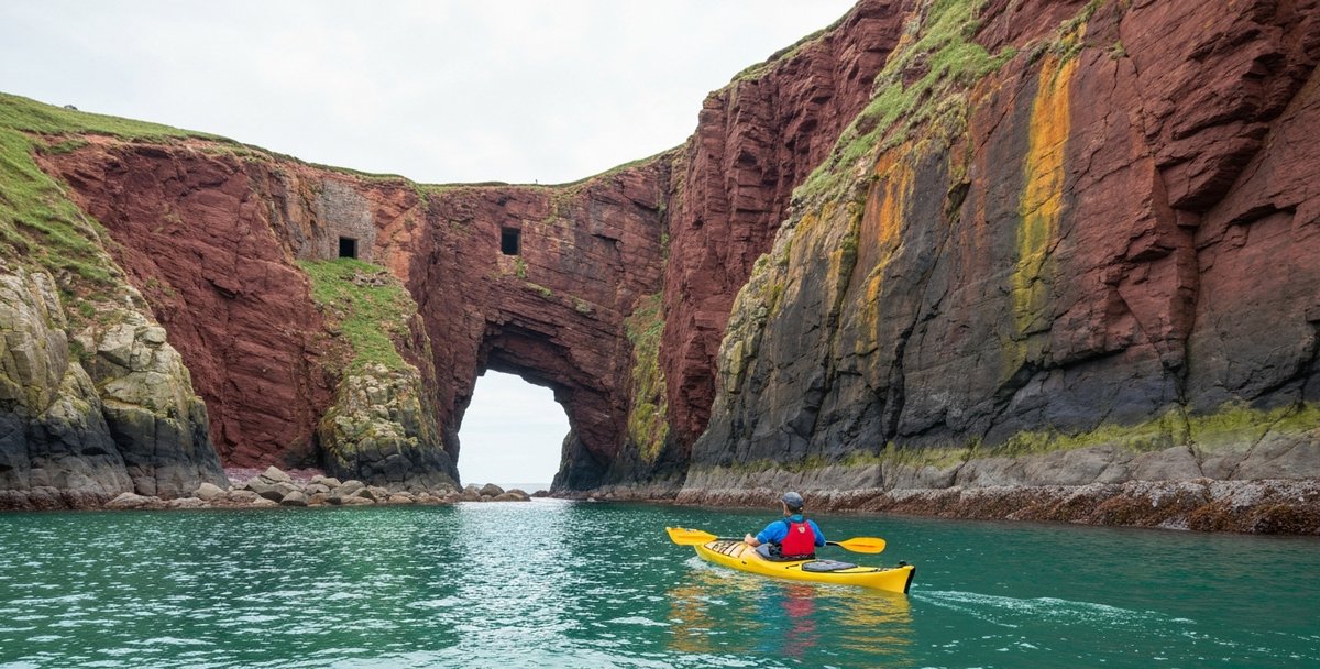
For kayakers, the Copper Coast is among the finest sea kayaking destinations in the south of Ireland. The cliff architecture is spectacular and constantly varied: purple-and-grey slates fractured into vertical columns at some headlands, then broad red sandstone platforms at others, then white quartz veins cutting across dark rock faces in patterns that look almost intentional. Sea arches, sea stacks, deep zawns (narrow cliff inlets), cave systems, and boulder beaches appear in sequence along the route. The beaches — Kilfarrasy, Dunabrattin, Annestown, Bunmahon — serve as natural staging points and emergency exit points between the cliff sections, and most are reachable by road, which makes multi-day paddling along the coast relatively straightforward to plan and shuttle.
The standard way to kayak the Copper Coast is in sections, starting or finishing at the beach access points. A full end-to-end paddle from Tramore to Dungarvan is a multi-day journey for experienced sea kayakers, typically broken into two or three days with overnight camping at the beach access points (wild camping under Leave No Trace principles; no formal campsites directly on this stretch of coast). Day sections of 8-12 km are more accessible and allow paddlers to cover specific geological features without committing to the full traverse.
The section between Kilfarrasy and Annestown (roughly 5 km) is widely considered the most rewarding single day section on the Copper Coast for intermediate sea kayakers. The cliffs are at their most varied here, there are several accessible caves and zawns, the landing options at Annestown beach are clear, and the paddle can be combined with a visit to the Copper Coast Geopark visitor centre at Bunmahon. A useful loop, often used by guided groups, starts at Bunmahon beach, heads west to Dunabrattin Head, and returns to Bunmahon — roughly 10 km of paddling that captures the finest section of the Geopark without requiring a full traverse.
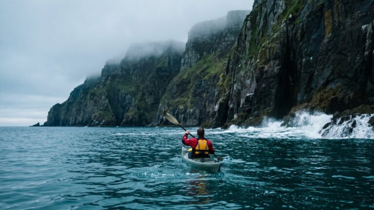
Wind and swell exposure on the Copper Coast is a serious consideration. The full coastline faces south-west to south-east with nothing between it and the Atlantic at its most exposed points. South-westerly swells arrive here with the full fetch of the North Atlantic behind them, and even relatively modest swell heights of 1.5–2m, combined with a rocky shore and no beach escape, create conditions that are only appropriate for competent sea kayakers with reliable self-rescue skills. The published recommendation from most operators and guides working this coastline is to treat it as an advanced venue at its exposed headlands, requiring at least Canoeing Ireland Sea Kayak Level 3 or equivalent experience and a minimum group size of three paddlers with appropriate safety kit. On calm summer days — and there are many of them in June, July and early August on the south coast — the Copper Coast in good weather is one of the most enjoyable paddles in Ireland. In deteriorating conditions, it is unforgiving.
Pure Adventure, based at Tramore, is the most visible commercial operator working the Copper Coast. They offer guided sea kayaking tours on the Geopark coastline, typically half-day and full-day sessions, at prices that have in recent years run in the range of €45-65 per person depending on group size and duration. Exact 2026 pricing should be confirmed directly. Their tours are well-regarded and their guides know the coastline in detail; for visitors who do not want to self-plan a Copper Coast paddle, a guided session with Pure Adventure is the most straightforward route to experiencing the Geopark by water.
Several Canoeing Ireland affiliated sea kayak coaches and guides also operate on the Copper Coast on an ad hoc and scheduled basis; the Canoeing Ireland website maintains a current listing of coaches available for hire in each province.
Key logistics — Zone 5:
- Primary access beaches: Kilfarrasy, Annestown, Bunmahon, Dunabrattin (all have car parks; some have toilet facilities)
- Difficulty: Intermediate to Advanced; experienced sea kayakers only at exposed headlands
- Operators: Pure Adventure (Tramore); Canoeing Ireland coach directory for independent guides
- Swell exposure: Full Atlantic; south-westerly swell is the dominant hazard; check Irish Weather Buoy Network for swell height and period
- Emergency landing: Pre-identify beach access points for every section before setting out
- UNESCO Geopark visitor centre: Bunmahon
Sea Kayaking the Waterford Coast — Conditions, Routes and Skill Level
Pull the five coastal zones together and a clear sea kayaking proposition emerges. The Waterford coast offers something most of the east-coast counties cannot: genuine ocean exposure inside a single short county shoreline. If you are planning a broader tour of Ireland’s sea paddling destinations, our sea kayaking Ireland guide puts Waterford in full national context. From the relatively sheltered shipping channel at Dunmore East, the coast turns west into open Celtic Sea swell at Tramore Bay, then continues into the cliff-bound, cave-pocked geological theatre of the Copper Coast Geopark. Three different sea kayaking environments inside roughly forty kilometres of shoreline.
Skill level varies dramatically by zone. Tramore Backstrand and the inner harbour at Dunmore East are realistic objectives for confident novices with rescue practice. The exposed sections of the Copper Coast between Annestown and Ballydowane are intermediate-to-advanced territory — committing cliff-line paddling with limited landing options, where Atlantic swell wraps around headlands and refracts off rock. Bunmahon to Stradbally is the most consequential stretch on the entire Waterford shoreline and is sensibly attempted in groups, with a forecast under 1 m swell and offshore or light winds.
The boat that matches this coast is a proper sea kayak — fibreglass or composite, full-length, with bulkheads, perimeter lines, deck pump and tow line. Recreational sit-on-tops can manage the Backstrand and Dunmore harbour on benign days, but anything beyond those two micro-environments demands a touring boat and the skills to roll, T-rescue and self-rescue in cold water. Check the Met Éireann marine forecast for the Carnsore Point to Mizen Head area before launch, and treat any small-craft warning as a hard stop.
The River Suir — Inland Extension
Above Waterford City, the River Suir becomes a different proposition entirely. The tidal influence extends upstream to Carrick-on-Suir, meaning that for the full 27 km from the city to Carrick the river is technically tidal, but the practical effect diminishes significantly as you move upstream. In the upper tidal section, around Kilsheelan and the reaches immediately below Carrick-on-Suir, the river feels and behaves much more like a lowland freshwater river than an estuary. The flow is gentle, the banks are tree-lined farmland, herons stand in the shallows, and the only tide-related variable is a slight lifting or lowering of water level rather than any meaningful current reversal.
The stretch of the Suir between Carrick-on-Suir and Waterford City is one of the most scenic flatwater touring paddles in Munster. The river passes through the Comeragh foothills on its right bank and broad farmland on the left, with small riverside towns providing optional takeout and resupply points. The Clonmel to Carrick-on-Suir section is part of the broader Suir Blueway concept, a river paddling trail that has been developed over recent years and in 2026 remains partially formal and partially informal in terms of access and facilities. For the most up-to-date blueway access information, see our guide to blueways in Ireland.
For a Waterford-based paddling trip, the most practical inland route is the section from Carrick-on-Suir downstream to Waterford City, running with the current and the outgoing tide once you reach tidal water. This is a full-day paddle of roughly 27 km. It requires a vehicle shuttle — Carrick-on-Suir to Waterford City takes about 25 minutes by road. Launch access at Carrick-on-Suir is from the Ormond Castle slipway or the town bridge area; both are accessible and have car parking within 200m.
The river between Carrick and the city is suitable for beginners in the non-tidal upper section (above Fiddown Bridge) and for confident intermediate paddlers on the tidal reaches closer to the city. The Comeragh Mountains, visible from the river at several points, add a pleasing backdrop, and the Ormond Castle in Carrick-on-Suir — a sixteenth-century manor house attached to a medieval tower — is visible from the river at launch.
Paddling Clubs in County Waterford
Waterford has an established club scene that offers a genuine route into paddling for those who want structured progression rather than independent tours. For the broader picture across Ireland, see our guide to kayaking clubs in Ireland.
Waterford Kayak Club is the primary flatwater and sea kayaking club in the county. Based on the River Suir, the club runs regular paddles on both the estuary and the Copper Coast, offers training sessions for beginners, and organises occasional multi-day coastal trips along the Geopark. New paddlers are encouraged to contact the club via their Canoeing Ireland listing before arriving at a session.
Tramore Kayak Club operates from the Tramore area with a focus on sea kayaking along the Copper Coast and the Tramore Bay coastline. The club has developed strong links with the Geopark educational programme and occasionally runs paddle tours timed to coincide with guided geological interpretation of the coastline.
For whitewater paddlers visiting the county, the Comeragh Mountains hold several small river systems that produce paddleable water after heavy rainfall — the Tay and Mahon rivers among them — but these are spate-dependent and not predictable enough to plan a trip around. The standard recommendation for Waterford-based whitewater is to cross the county boundary into Tipperary (River Nore headwaters, upper Suir tributaries) when the right rain has fallen.
Getting There
From Dublin: Waterford is approximately 2.5 hours by car via the M9/N25 motorway route through Carlow and Kilkenny. The train from Dublin Heuston to Waterford takes about 2 hours, making it one of the more car-free accessible paddling destinations in the south-east — though you will need either to hire equipment in Waterford City or join a guided tour if you are arriving by train.
From Cork: Waterford is about 1.5 hours from Cork City via the N25. The Waterford-Rosslare rail line provides an alternative for paddlers who want to link Waterford with a Wexford-based trip.
For the Copper Coast specifically: The beach access points at Kilfarrasy, Annestown and Bunmahon are all reached from the R675 coast road, which runs along the Copper Coast from Tramore to Dungarvan. Each beach has a signed turnoff and a car park; some car parks charge a seasonal fee from June to August.
Accommodation: Waterford City has a full range of hotels and guesthouses; the Granville Hotel on the quays is the most atmospheric option for a city-based stay. Tramore has abundant B&B and self-catering accommodation. Dunmore East has a small number of holiday cottages and one hotel above the harbour. For multi-day Copper Coast paddlers, the most practical base is Tramore for eastern sections or Dungarvan for western sections.
Tides, Weather and Safety
Tidal Planning
Waterford’s tidal regime is driven by the Atlantic tide arriving at the harbour mouth and progressing upstream into the estuary system. The key tidal reference port is Waterford, with secondary port corrections needed for Dunmore East, Cheekpoint, and the upper Suir. Irish Tidal Tables (published by the Marine Institute) are the authoritative source; Tideschart.com and the UKHO EasyTide service all provide usable tidal predictions for Irish ports.
The most important tidal rules for Waterford paddlers are:
Spring tides (near full and new moon) generate faster currents and more extreme water level changes throughout the system. The 3.5-knot ebb alongside the city quays is a spring figure; neap currents are significantly slower. If you are new to Waterford, plan your first paddles on neap tides.
The Three Sisters confluence around Cheekpoint is particularly complex on spring tides. Three tidal rivers converging at the same point creates local eddies, counter-currents and steep chop that does not appear on any tide table — only local experience and water-reading skills can manage these effectively.
The Backstrand at Tramore drains to near-empty on low water. Access the Backstrand only within 2 hours either side of high water on any tide. On springs, approach the Rinnashark channel with caution.
The Copper Coast tidal streams run roughly east-west. On the Copper Coast, the flood tide sets eastward (toward Dunmore East) and the ebb sets westward (toward Dungarvan). Understanding this is critical for planning coastal traverses: paddling with the tidal stream doubles your effective speed; paddling against it can reduce you to near-stationary in a headwind.
| Season | Months | Water Temp | Thermal Protection | Recommended Zones | Notes |
|---|---|---|---|---|---|
| Winter | Dec–Feb | 8–9°C | Drysuit essential | Zone 1 (experienced only); Zone 3 calm days only | Zones 2 & 5: avoid; Backstrand: bird season |
| Spring | Mar–May | 10–12°C | 5mm wetsuit minimum | Zones 1, 3, 4 open; Zone 5 check swell | Backstrand: birds Mar–Apr; Zone 5 from Apr with care |
| Summer | Jun–Sep | 14–17°C | 3mm wetsuit | All zones open | Zone 2 spring tides caution; Aug = warmest water (17°C) |
| Autumn | Oct–Nov | 14°C → 11°C | 3mm → 5mm wetsuit | Zones 3 & 5 excellent; all others open | Brent geese arrive Sep–Oct in Backstrand; water cools rapidly Nov |
Weather and Wind
The Waterford coast is exposed to south-westerly airflow from the Atlantic. The typical summer pattern features south-westerly winds of Force 3-4 with occasional periods of light northerlies or easterlies in high-pressure systems. The windows of best sea kayaking weather tend to occur in June and early July before the Atlantic weather pattern becomes more unsettled. August can be excellent but is less reliable.
For sea forecasting, the Met Éireann small craft warnings (broadcast on VHF Channel 16/83 and available on the Met Éireann website and app) provide specific warnings for Irish coastal waters. For the Copper Coast specifically, a swell height of more than 1.5m at the M5 Celtic Sea buoy typically means rough conditions at the exposed headlands even if local wind is light.
Safety Kit
For the estuary (Zones 1-2): buoyancy aid, paddle, waterproof phone or VHF radio, tow line, tide tables, first aid kit. Tell someone your planned route and expected return time.
For Dunmore East and the bay (Zone 3): as above, plus dry suit or wetsuit appropriate to season, spare paddle, and a plan for the nearest lifeboat station (Dunmore East RNLI is on the pier).
For the Copper Coast (Zone 5): full sea kayaking safety kit — buoyancy aid, dry suit, spare paddle, tow line, VHF radio, deck compass, chart or chart app, emergency bivouac gear if overnight paddling, EPIRB or PLB for remote sections. Minimum group size of three; do not paddle alone on exposed sections.
The Canoeing Ireland website publishes a comprehensive safety guide for sea kayaking in Ireland; it is required reading before paddling any exposed sections of the Copper Coast.
Shipping Traffic
Waterford Port handles commercial vessels at all hours. The main shipping lane runs from Hook Head through the harbour to Belview Port. Kayakers should stay well clear of the marked shipping channel, monitor VHF Channel 16 for harbour traffic broadcasts, and treat any approaching commercial vessel as an absolute priority — they cannot stop or easily deviate.
What to Expect in Each Season
Spring (March-May): Water temperatures are cold — typically 9-12°C at this coast — making a dry suit essential for capsize recovery. Days are lengthening, however, and spring in south-east Ireland can deliver some remarkably settled weather. The Copper Coast is at its birdiest in spring, with breeding seabirds returning to cliff faces. Expect fewer boats, no crowds at beach access points, and full tidal range on spring tides.
Summer (June-August): The peak season. Water temperatures rise to 14-17°C by August, making wetsuits practical. The Copper Coast and Dunmore East are at their most visited and operators are at full capacity; book guided tours well in advance. The long Irish summer evenings allow paddling into the late evening in June and July — the light at 9pm on the Copper Coast is extraordinary.
Autumn (September-October): Arguably the finest season for coastal sea kayaking on this coast: water temperatures hold from summer, days are less crowded, and the angle of autumn light across the cliffs is different to anything available in summer. September in particular often delivers long stable periods. The Backstrand at Tramore begins to fill with wintering wildfowl in September, adding a wildlife dimension to any paddle.
Winter (November-February): For experienced paddlers only. Conditions are frequently unsuitable for the exposed sections, but the estuary and city sections are paddleable in calm windows. The birding on the tidal Suir and Backstrand in winter is exceptional. Dry suit is non-negotiable.
Kayak Rental, Hire & Lessons in Waterford — 2026 Operators
Guided Tours and Instruction
Pure Adventure, Tramore Pure Adventure is the leading sea kayak operator on the Copper Coast, offering guided half-day and full-day tours along the Waterford Geopark coastline. Tours are designed for both complete beginners (on calmer sections) and intermediate paddlers wanting to explore the cliff scenery. Prices in recent years have run approximately €45-65 per person; confirm current 2026 rates directly with the operator. Pure Adventure also offers SUP tours on the calmer stretches of the bay. Website: pureadventure.ie.
Dunmore Adventure Centre, Dunmore East Based at the harbour, the centre offers guided kayak tours around the coves and bay north of the village. Suitable for beginners and families; tours are generally 2 hours and guided throughout. Pricing is in the €30-45 range depending on group size. Book in advance during July and August. Website: dunmoreadventure.ie.
Independent Canoeing Ireland Coaches Several coaches registered with Canoeing Ireland operate guided paddles in Waterford and on the Copper Coast on a private basis. For custom tours — particularly bespoke multi-day estuary or coastal paddles — contact the Canoeing Ireland coach directory. Rates vary but full-day private guiding typically runs €150-250 per day for a group of up to 4.
Kayak Hire
Kayak hire for self-guided paddling on the River Suir and estuary is available through a small number of local operators; the availability changes year to year and interested paddlers should check current listings on the Canoeing Ireland website or contact Waterford Kayak Club for recommendations. For a broader view of kayak hire across Ireland, see our guide to kayak rental in Ireland.
Courses
Canoeing Ireland runs regular national-standard kayaking courses at venues in Waterford; the Waterford Kayak Club is the typical course venue for structured progression in the county. Beginner sea kayaking courses, typically run over a weekend, cover basic paddle strokes, wet exits, assisted rescues, tidal awareness and coastal navigation. Day courses are available for paddlers who want a single session of instruction without full weekend commitment.
Also Read
For related paddling destinations and planning resources elsewhere in Ireland:
- Kayak Rental Ireland — Where to Hire a Kayak in Every County
- Blueways Ireland — Complete Guide to Ireland’s Paddle Trails
- Kayaking Killarney — Lakes, Rivers and the Ring of Kerry by Kayak
- Kayaking West Cork — Sea Caves, Islands and the Mizen Peninsula
- Sea Kayaking Ireland — Complete Guide for 2026
- Kayaking Wicklow — Sea Cliffs, Glens and the Wicklow Blueway
Frequently Asked Questions
Is kayaking in Waterford suitable for beginners?
Yes, with the right zone and conditions. The harbour and bay at Dunmore East on a calm day, the guided tours run by Dunmore Adventure Centre, and the beginner sessions at Tramore Pier are all appropriate for complete beginners. The estuary sections and the Copper Coast are not beginner venues — they require tidal awareness and open-water experience. The safest route for a beginner is to join a guided tour with Pure Adventure on the Copper Coast or Dunmore Adventure Centre at the harbour, where all equipment is provided and an instructor is present throughout.
What is the best time of year to kayak the Copper Coast?
June, September and early October are typically the best months. June has long evenings, relatively stable weather and a settled pre-summer Atlantic pattern. September and October combine warm water (summer temperatures persist into autumn), quieter beaches, excellent light and fewer other boats. July and August are the busiest months but also reliable for weather. Avoid exposed coastal paddling from November to March unless you are an experienced sea kayaker comfortable in cold-water conditions.
Do I need a licence to kayak on the River Suir?
There is no paddle craft licence required to kayak on tidal waters in Ireland, including the tidal Suir. Above the tidal limit (around Carrick-on-Suir), the rules differ depending on the waterway owner; Waterways Ireland manage some stretches. For the purposes of most Waterford paddling — the estuary, the harbour, the coast — no licence is required. A VHF radio, if carried, requires a ComReg Short Range Certificate to operate legally.
Is the Backstrand at Tramore safe for kayaking?
With careful planning, yes. Paddle only within two hours either side of high water on neap tides; the lagoon drains to near-empty on low water. The Rinnashark channel at the entry point generates strong currents on springs. The lagoon contains documented quicksand in places. It is an SAC and SPA conservation area; seasonal access restrictions may apply, and paddlers should minimise disturbance to roosting and nesting birds. For a first visit, joining a guided tour with a local who knows the tidal behaviour inside the lagoon is strongly recommended over independent exploration.
What sea kayaking experience do I need for the Copper Coast?
The exposed headlands on the Copper Coast require at least Canoeing Ireland Sea Kayak Level 3 or BCU equivalent, plus practical open-water experience that includes capsize recovery in sea conditions, self-rescue and assisted rescue, reading tide streams and understanding swell. For calmer beach-to-beach sections in light conditions, an intermediate paddler who has completed a sea kayaking skills course should be capable. If you are unsure of your level, go with a guide from Pure Adventure for your first Copper Coast session.
Can I kayak to Hook Head from Dunmore East?
Yes, but it is a serious proposition. The return distance is approximately 16 km; the tidal race off Hook Head generates powerful and unpredictable water in certain conditions; there are no practical beach landings for much of the approach from the north; and the sea conditions can deteriorate rapidly on this exposed headland. This paddle is only appropriate for competent sea kayakers. Check tidal streams for the Hook Head race carefully using the Irish Sea Pilot or appropriate chart source, and plan to arrive at and depart from the headland at slack water.
Where should I launch for the Waterford City estuary paddle?
The Boat Club slipway at Merchants Quay, at the western end of the quays, is the most used launch point for city-based paddling. There is limited roadside parking nearby; city centre car parks are within 800m. For a downstream float to Cheekpoint, time your launch to coincide with the ebb tide beginning, approximately 30 minutes after high water at Waterford. Avoid launching into a strong spring ebb without a clear plan for your exit.
What is the Copper Coast Geopark and why is it worth paddling?
The Copper Coast Geopark is a UNESCO Global Geopark covering approximately 25 km of coastline in County Waterford, designated for its exceptional geological diversity: Ordovician-Silurian rock sequences up to 460 million years old, Carboniferous limestone, Old Red Sandstone and Caledonian granite, all exposed in sea cliffs that tell a continuous story of continental collision, erosion and marine sculpting. The name comes from nineteenth-century copper mining in the cliffs. From a kayak the geological variety is vivid — colour changes in the cliff faces are striking even to non-geologists — and the wildlife (breeding seabirds, grey seals, occasional basking shark in summer) adds to the experience. It is the finest continuously varied sea cliff paddling in the south-east of Ireland.
What wildlife can I expect to see kayaking in Waterford?
The estuary is excellent for birds at all seasons: little egret, grey heron and kingfisher are regular on the tidal Suir; curlew, redshank and oystercatcher work the mudflats. In winter, the Backstrand holds brent geese, wigeon, dunlin and golden plover in the thousands. The Copper Coast cliffs host guillemot, razorbill, fulmar, kittiwake and shag. Grey seals are a regular sighting along the Copper Coast and around Dunmore East; common dolphins appear in the harbour mouth in summer. Basking sharks are seen occasionally in calm summer conditions offshore along the Geopark coast.
Where can I go kayaking near Tramore?
Tramore has two distinct paddling options. Tramore Pier, on the eastern side of the bay, is the most accessible launch point and the venue for structured beginner lessons — sheltered, easy to exit regardless of tide, and suitable for those new to sea kayaking. The Backstrand, the large tidal lagoon behind the dunes, is the other option: ecologically spectacular, flat-water when accessed correctly, but tide-dependent and not recommended for beginners without a guide. The open Tramore Bay itself — the 5-km stretch between the pier and Newtown Head — is a moderate sea kayak route in settled conditions, best in northerly or westerly winds when the bay is in a lee. For guided access to the Backstrand and the bay, Pure Adventure in Tramore is the main local operator.
What is River Suir kayaking like, and how does it connect to the Waterford estuary?
River Suir kayaking divides into two distinct experiences. Above Waterford City, from Carrick-on-Suir downstream, the Suir is a gentle flatwater touring river passing through Comeragh foothills and farmland — a scenic day route that suits confident beginners and intermediates. Below the city, the Suir becomes tidal, with spring ebb currents reaching 3.5 knots alongside the medieval quays. The standard downstream route — city quays to Cheekpoint, roughly 8 km — transitions from urban tidal river into the full Waterford estuary at Cheekpoint, where the combined Barrow-Nore flow joins the Suir and the water broadens into the harbour. The estuary itself is the largest paddling waterway in the south-east, running from Cheekpoint out to Hook Head and feeding into the open approaches to Dunmore East and the Copper Coast. The full journey from Carrick-on-Suir to the estuary mouth covers about 35 km and is a natural multi-day itinerary — river touring in the morning, open-water paddling by afternoon.
Are there guided kayak tours that include the Viking history of Waterford?
Not as a formally packaged product, as of 2026. Some operators and independent guides include commentary on Waterford’s Viking and medieval heritage when paddling the city estuary past Reginald’s Tower and the quays, but there is no commercial Viking kayak tour operating in Waterford in the way that exists around Dublin’s coastal heritage. For now, the best way to combine the city’s history with paddling is to paddle the city stretch independently (or as part of a club paddle) and arrange a separate visit to the Waterford Museum of Treasures, which houses Viking artefacts from the city’s extensive archaeological excavations.
Planning Your Trip — Summary
Waterford rewards paddlers who take it seriously. The estuary system is one of the most historically layered paddling environments in Ireland — Viking foundations, medieval walls, a working commercial port, and an active tidal river system all in a single day’s paddle from the city. The Copper Coast is among the finest sea kayaking coastlines in Munster, offering geological spectacle and wildlife that rival anything on the better-known west coast. Dunmore East gives a compact, beginner-accessible harbour setting with sea cliff interest on its doorstep. And the Backstrand at Tramore, properly understood and tidally respected, is a wildlife sanctuary that can be experienced from the water in a way unavailable to walkers.
The key to Waterford is planning around the tides. This is not a county where you arrive, unload the kayak, and head off regardless of the water state. The Suir’s 3.5-knot spring ebb, the Rinnashark channel at Tramore, the tidal stream off Hook Head, and the drainage cycle of the Backstrand all demand that you check the tide tables the night before and build your day around them. Do that, and Waterford is as good as anything Ireland’s paddling scene offers.
For beginner-friendly access, book with Pure Adventure for the Copper Coast or Dunmore Adventure Centre for the harbour coves. For independent paddlers with open-water experience, the estuary float from Waterford City to Cheekpoint is a half-day classic that stands comparison with any Irish river paddle, and the Copper Coast section from Kilfarrasy to Annestown is a day-trip benchmark worth driving from anywhere in the country to complete.
Waterford: big tides, Viking history, one UNESCO Geopark, three rivers meeting the sea, and not nearly enough kayakers on it yet.
All operator pricing quoted as approximate 2026 figures based on recent historical rates. Confirm current prices directly with each operator before booking. Tidal information is indicative; always verify against current Irish Tidal Tables and Met Éireann marine forecasts before paddling. Safety information in this guide supplements but does not replace formal paddling instruction and qualification.

No comments yet on this route.
Be the first to share your experience — conditions, access, hazards, or anything a future paddler should know.
Login to join the discussion