West Cork is the best stretch of coast on the island of Ireland for kayaking. The bays are sheltered. The islands run for miles. The Beara, Sheep’s Head, and Mizen peninsulas split the Atlantic into a dozen separate paddling zones. And tucked between them, Lough Hyne — Europe’s first statutory marine reserve — glows at night with bioluminescent plankton.
This guide maps every paddleable spot in West Cork, explains what each one suits, covers safety on a coast that gets serious quickly, and tells you when and where to go. Written for paddlers — beginner, intermediate, and improver — not for tour brochures.
What Makes West Cork’s Coast Special
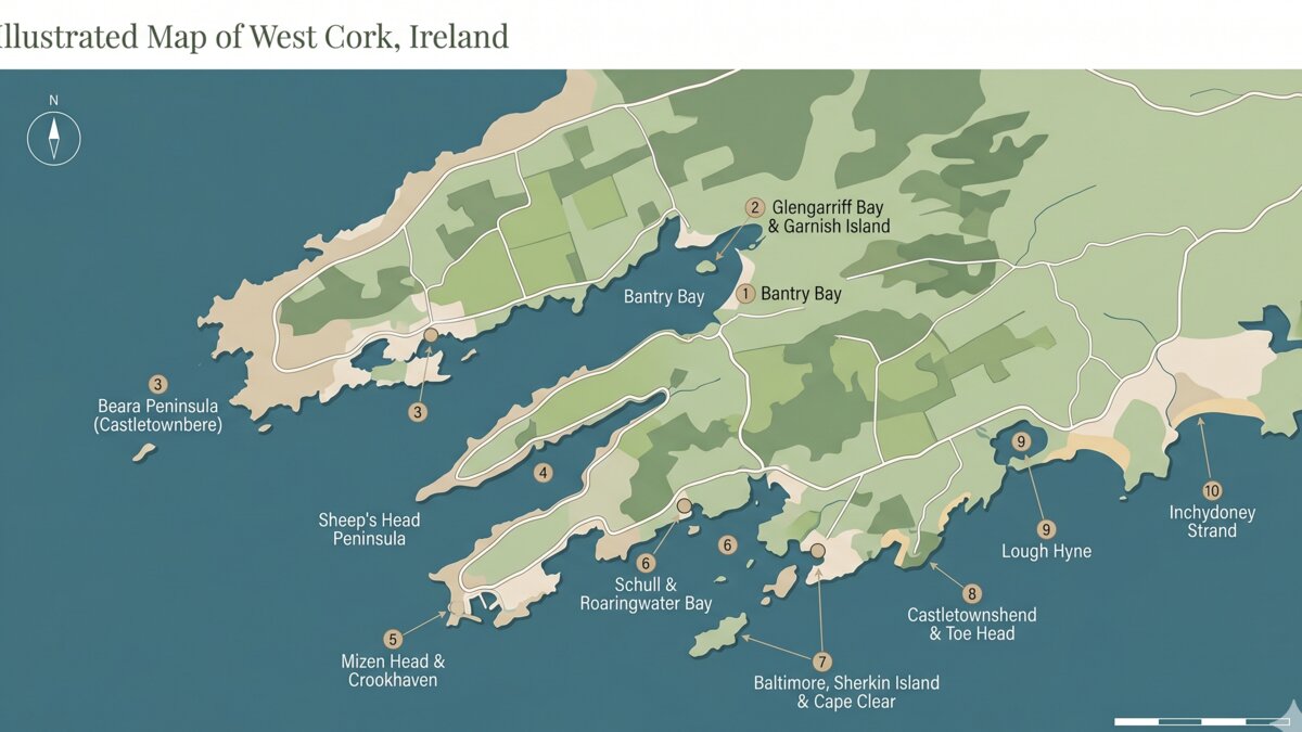
The geography does the work. West Cork’s coast runs roughly from Cork Harbour west to Dursey Island, and along the way it folds in on itself again and again. Three peninsulas — Beara in the north, Sheep’s Head in the middle, and Mizen in the south — each create their own bay system. The bays themselves are layered with islands, headlands, and inlets that block Atlantic swell while still giving access to open water when you want it.
That layering matters. On a settled day you can paddle the open Atlantic side of Mizen and feel the swell of the open sea. The same day, two hours’ drive away, you can paddle Bantry Bay in flat water with mountains on three sides. No other Irish region gives you that range in such a small area.
The other thing West Cork does better than anywhere else in Ireland is wildlife. Grey seals haul out on rocks across Roaringwater Bay and Bantry Bay. Bottlenose dolphins are regulars off Mizen and around the Mizen-to-Sheep’s Head crossing. Minke whales and basking sharks pass offshore between May and September on Atlantic feeding migrations. From a kayak, at eye level with the water, you see all of this differently than from a tour boat.
Where to Kayak in West Cork — Every Worthwhile Spot
This section walks through the West Cork coast roughly north to south, by peninsula and bay. Each spot is graded for difficulty, with launch points and what to expect.
Bantry Bay — Sheltered Start, Mountain Backdrop
Bantry Bay is the standard West Cork starting point. The inner bay between Bantry town and Whiddy Island is exceptionally sheltered — the Caha Mountains on the Beara side and the hills above Bantry block most wind. Launch from Bantry pier and you have a 1.5 km crossing to Whiddy Island, with seals usually visible around the rocks at the eastern tip.
Whiddy itself is worth the paddle. The ruins of Napoleonic-era martello towers stand on the shoreline, and the south shore has small sandy coves for landing. The Betelgeuse memorial on the island marks one of Ireland’s worst maritime disasters (1979) — a sombre but important stop.
For the full route, see the WaterEgo page on Bantry Bay. Suits: beginners, intermediates. Distance: 3-11 km depending on whether you do the Whiddy circumnavigation.
Glengarriff Bay & Garnish Island
Glengarriff Bay is tiny, tree-lined, and the most forgiving open-water paddle in Munster. The bay sits inside a natural harbour at the head of Bantry Bay, sheltered by Garnish Island (Ilnacullin) and the wooded shoreline. The island’s Italianate gardens were laid out in the 1910s and are managed by the OPW today.
The standard paddle is a 4 km loop from Glengarriff pier out to Garnish, around the island, and back. Seals are common on the rocks at the island’s western end. The water is sheltered enough that this works as a true first open-water paddle for someone with one or two pool sessions behind them.
For the route detail, see Glengarriff Bay. Suits: beginners, families. Distance: 4-6 km.
Beara Peninsula — Castletownbere, Adrigole, Bere Island
The Beara coast runs from Glengarriff west to Dursey Island, and the paddling escalates as you go. Adrigole Harbour, a few kilometres west of Glengarriff, has a small pier and access to the inner bay below the Sugar Loaf and Hungry Hill mountains. Castletownbere — Ireland’s largest white fish port — sits another 30 km west and gives access to Bere Island just across the channel.
Bere Island itself is 11 km long and is fully circumnavigable in a day for fit intermediate paddlers. The crossing from Castletownbere to Rerrin (the main village on Bere) is roughly 1.5 km and crosses the main shipping lane — keep close watch on fishing traffic and the Bere Island ferry. Once on the island, the southern shore opens onto fully exposed Atlantic water suitable only for advanced paddlers in settled conditions.
Suits: intermediate to advanced, depending on which section. Distance: 5-25 km.
Sheep’s Head Peninsula
The smallest of the three peninsulas, Sheep’s Head separates Bantry Bay from Dunmanus Bay. Both sides have launch options. Ahakista on the southern (Dunmanus) shore gives access to a sheltered cove suitable for beginners. Kilcrohane, further west, is more exposed and faces directly onto the long fetch of Dunmanus Bay — strictly for experienced paddlers on settled days.
The Sheep’s Head peninsula coast is mostly inaccessible by road, which makes the paddle perspective the only way to see significant stretches. Choughs (the rare crow species with the red beak) nest on the cliffs along the southern shore.
Suits: intermediate. Distance: 6-15 km depending on segment.
Mizen Head & Crookhaven
Mizen Head is the south-westernmost point of mainland Ireland and an exposed paddling zone. Conditions here are usually bigger than anywhere else in West Cork — full Atlantic swell rolls into the headland on a south-westerly. Not a beginner spot.
Crookhaven, on the south side of the Mizen peninsula, is the more accessible base. Launch from the pier at Crookhaven village into a sheltered inlet, then paddle west towards Mizen Head on a settled day with light offshore wind. Barley Cove, just east of Crookhaven, is a sand-bottomed bay that flattens out in onshore wind — useful as a beginner alternative when Mizen itself is out.
Suits: intermediate to advanced. Distance: 5-20 km.
Schull & Roaringwater Bay
Roaringwater Bay is the central jewel of West Cork paddling. It runs roughly 12 km long and 6 km wide, partially sheltered from Atlantic swell by the Mizen Peninsula in the south and a chain of islands across its mouth. Inside the bay there are over a dozen islands — Heir, Long Island, Castle Island, Calf Islands, Sherkin, Cape Clear, Hare Island — most of which are landable.
Schull is the most popular launch point. The pier in the village gives sheltered access, and the standard intermediate paddle is the 8 km round-trip to Long Island or the 15 km loop taking in Heir and the Calf Islands. Roaringwater Bay is the single best Irish destination for island-hopping by kayak.
Suits: beginners (inshore from Schull) to advanced (open crossings). Distance: 4-25 km.
Baltimore, Sherkin Island & Cape Clear
Baltimore village sits on the eastern shore of Roaringwater Bay and is the ferry port for Sherkin and Cape Clear. The kayak crossing from Baltimore harbour to Sherkin Island is roughly 1.5 km and crosses the ferry route — time the paddle to avoid scheduled ferry movements.
Sherkin is a small island with a sheltered eastern shore and a more exposed western face that drops to the open Atlantic. The Beacon — a white-painted navigation tower on the south-eastern headland of Sherkin — is the navigation landmark for the area and is visible from kilometres out. Cape Clear is further offshore (roughly 6 km from Baltimore) and is a committed open-water crossing best left to experienced paddlers in settled conditions.
Suits: intermediate. Distance: 4-20 km.
Castletownshend & Toe Head
Castletownshend is the home base of the leading commercial sea kayaking operator in West Cork, which means the village pier is a launch point for guided tours daily during the season. Independent paddlers are welcome to use the same launch. The bay below Castletownshend is partially sheltered by Horse Island and gives access to Toe Head 4 km to the south.
Toe Head is the start of the wilder coast — the cliffs east of the headland are paddleable only in calm conditions, and the sea caves here are some of the most dramatic on the south coast. Inside the village, the harbour itself is dead flat in most weather and works as a beginner spot for a half-hour first paddle.
Suits: beginners (harbour) to advanced (Toe Head). Distance: 3-15 km.
Lough Hyne — Europe’s First Marine Nature Reserve
Lough Hyne deserves its own section. It is a tidal saline lake — connected to the sea by a narrow channel called The Rapids — and the only fully marine lake in Western Europe. Salinity is roughly equal to the open sea, but because the lake is enclosed and tidal exchange happens through the narrow channel, the water is unusually clear and the biodiversity is internationally significant. It became Europe’s first statutory marine nature reserve in 1981.
The lake itself is roughly 1 km across and surrounded by woodland. Launch from the small slipway on the western shore (signed from the road south of Skibbereen). The paddling is dead flat, sheltered on all sides, and ideal for beginners. The whole circumference can be paddled in a relaxed two-hour outing.
Wildlife on Lough Hyne includes purple sea urchins, sea fans, scorpion fish, and dozens of species more typically found in much warmer Mediterranean waters — the unique chemistry of the lake supports them. Goldsynge, the small island in the centre, is closed to landing to protect nesting birds.
Suits: beginners, families. Distance: 4 km full loop.
Inchydoney Strand & Clonakilty Bay
The east end of West Cork. Inchydoney is a long sandy strand outside Clonakilty, with a paddleable bay running west from the beach into the Clonakilty estuary. The estuary itself is shallow and tidal — paddleable at high water, mostly mud at low water. The open beach side is exposed to Atlantic swell but suitable for surf-kayak practice in moderate conditions.
Inchydoney is the busiest beach in West Cork from June to August, so launch early or pick a midweek day. The hotel on the strand provides parking and toilets that paddlers can use.
Suits: beginners (estuary at high tide) to surf paddlers (open beach). Distance: 3-8 km.
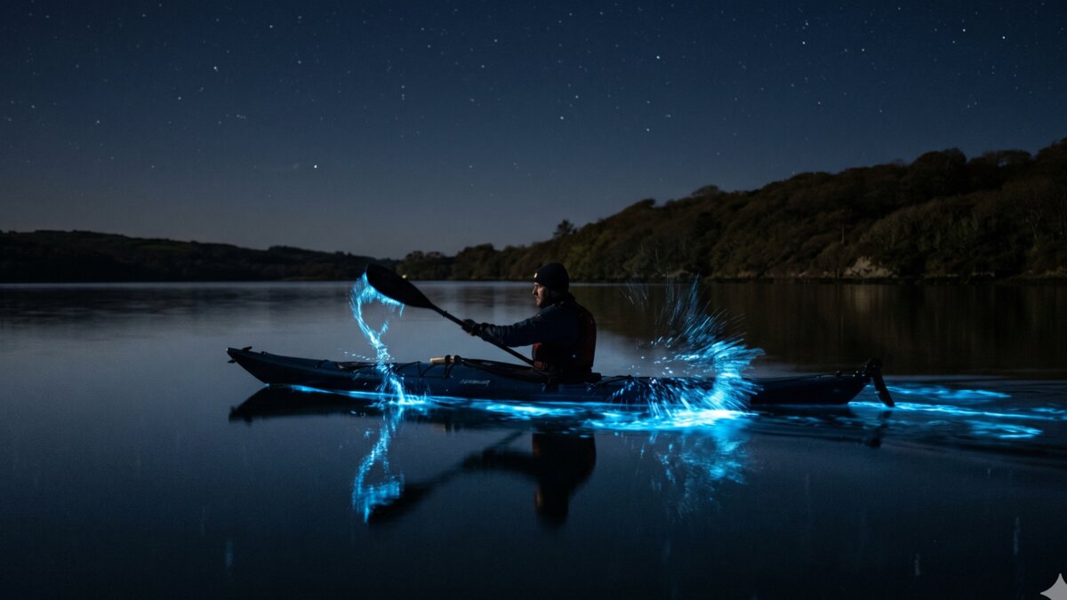
Night Kayaking in West Cork — Bioluminescence on Lough Hyne
The most-photographed paddle in Irish kayaking is a midnight Lough Hyne outing in summer when the water glows. Every dipped paddle stroke leaves a streak of cold blue light. Splashes scatter into clusters of tiny stars. This is real biology — not folklore.
What causes it
The light comes from a marine dinoflagellate called Noctiluca scintillans (and several related species). These are single-celled plankton that release a chemical called luciferin when disturbed. The reaction with luciferase produces a brief flash of cold blue light — the same biochemistry as a firefly, but in a microscopic ocean organism.
Lough Hyne supports an unusually dense population of these dinoflagellates because of its unique chemistry: full marine salinity, narrow tidal exchange through The Rapids, warm shallow surface water in summer, and shelter from surface mixing by surrounding hills. The combination concentrates plankton in a way the open sea cannot match.
When the bioluminescence appears
Peak season is June through September, with the best displays usually in late August and September when surface water is warmest and dinoflagellate populations are highest. Go on a moonless night — even a quarter moon dilutes the contrast significantly — and at least an hour after sunset for full dark adaptation.
Conditions matter too. Settled, windless nights show the best glow because surface chop disperses the plankton concentration. If a south-westerly has been blowing all day, the show is dimmer.
How to paddle it safely
This is night paddling on cold water. Do not improvise. The safe approach:
- Book a guided night tour. Several West Cork operators run summer bioluminescence trips. They supply boats, PFDs, glow-sticks for boat-spotting, and most importantly local knowledge of where the plankton are concentrating that week.
- If self-guided, paddle with at least one other person, have a fully charged phone in a waterproof case, leave a written float plan with a friend, and stay within the lake — do not paddle out through The Rapids in the dark.
- Wear a PFD, even on calm water. Especially on calm water — the temptation to skip it on a lake feels stronger than on the sea.
- Carry a light — a head torch with a red filter preserves your dark adaptation when needed, and gives you a way to see your boat and paddle.
Search terms like lough hyne bioluminescence and night kayaking west cork get over 200 monthly searches between them — the activity is real and growing, but it remains a niche skill set. Treat it accordingly.
When to Kayak — Best Time of Year for West Cork
The West Cork paddling season runs roughly Easter through October. Inside that window:
- April–May — quiet, water cold (8–10 °C), settled high-pressure systems give the year’s best paddling days when they line up. Wear a wetsuit minimum.
- June — the sweet spot for general paddling. Long evenings, water warming, low tour-boat traffic, hire operators fully open.
- July–August — peak. Tour operators booked out on weekends. Bioluminescence on Lough Hyne starts ramping. Tour boats more frequent on Roaringwater Bay.
- September — second sweet spot. Water still warm, peak bioluminescence season on Lough Hyne, fewer crowds.
- October — final month. Hire fleets winding down. Wetsuit weather. Atlantic depressions arrive more frequently.
Winter paddling on the sheltered inner bays (Bantry, Glengarriff, Lough Hyne) is possible for experienced paddlers in full immersion gear, but the open coast becomes serious quickly. Not for beginners.
What to Expect on the Water — Weather, Tides, Swell
West Cork is on the Atlantic. Conditions change fast. Three numbers matter every paddle.
Wind
The 50/90 rule that sea kayak coaches teach applies here cleanly. Add wind speed in knots to wave height in inches. Above 50 — experienced paddlers only. Above 90 — do not launch. On a clear day in Bantry Bay this might be 8 knots plus 2-inch chop = 10 (fine for any level). On a stiff south-westerly off Mizen, you can hit 90 easily.
The same Beaufort scale from sea kayaking applies. F4 is the line for most paddlers.
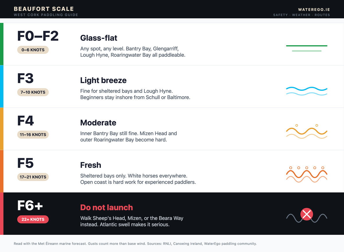
| Beaufort | Knots | What it means in West Cork |
|---|---|---|
| F0–F2 | 0–6 | Glass-flat. Any spot, any level. |
| F3 | 7–10 | Light. Fine for sheltered bays and Lough Hyne. |
| F4 | 11–16 | Moderate. Inner Bantry Bay still fine. Mizen and outer Roaringwater become hard. |
| F5 | 17–21 | Fresh. Sheltered bays only. White horses everywhere. |
| F6+ | 22+ | Stop. Walk Sheep’s Head instead. |
Met Éireann’s marine forecast covers South-West Connaught and South Coast (Mizen Head to Carnsore Point) twice daily. Read it before every paddle. Wind direction matters more than speed — offshore wind from the north pushes you out to sea on the open coast, even in light conditions.
Tides
Tidal range in West Cork averages 3-4 metres on springs, 1.5-2 metres on neaps. Tidal streams through narrow channels — the Sound between Sherkin and Heir Island, the channel at Castletownbere — can run at 2-3 knots. Plan to paddle with the tide on the outbound leg, especially in narrow channels.
The Lough Hyne Rapids reverse direction four times a day with the tide, and at peak flow run at over 4 knots through a 25-metre channel. Do not attempt to paddle through The Rapids. Lift out, walk around, re-enter in the lake or in the sea, depending on direction.
Swell
West Cork sits on the receiving end of Atlantic swell that has crossed thousands of kilometres. Even on a calm day with no local wind, swell from a distant storm can produce 2-metre waves on the outer coast. The Magic Seaweed forecast covers the West Cork coast — useful for surf paddlers and for anyone planning an outer-coast trip.
Wildlife — What You Will See from a West Cork Kayak
The wildlife is one of the reasons paddlers come back. From a kayak at sea level, you see all of this differently than from a boat or a clifftop.
- Grey seals — common across the Roaringwater Bay islands, Whiddy, and Sherkin. Pup season is September-November; keep at least 30 metres clear of haul-out rocks during this period.
- Bottlenose and common dolphins — Mizen waters, Bantry approaches, occasionally Roaringwater Bay. The pods that hunt off Mizen sometimes follow kayakers for several hundred metres before turning back.
- Minke whales and basking sharks — May to September, on the outer coast. Sightings unpredictable but real.
- Choughs — small black crows with red beaks and feet. Endangered globally, but Sheep’s Head cliffs have a stable breeding population.
- Gannets — the white seabirds that dive vertically into the water. Visible offshore around Mizen.
- Otters — quieter sightings on Lough Hyne and the Bantry Bay inlets at dawn and dusk.
Kayak-with-seals trips run commercially in Roaringwater Bay and Glengarriff. The principle is simple: do not pursue seals, let them approach you, and back off if they show any sign of distress.
Gear for West Cork Paddling
Coastal Irish paddling sits between sheltered blueway gear and full sea-kayak expedition gear. For the typical West Cork day-trip on Bantry, Lough Hyne, Roaringwater, or Glengarriff:
- Sea kayak or sit-on-top — 4.5 m+ for committed crossings, sit-on-top fine for sheltered bays.
- Spray deck — sit-inside boats only. Required for any paddle that may meet swell.
- PFD — ISO 12402-5 Level 50. On you, not in the boat.
- Wetsuit or drysuit — wetsuit (3-5 mm) acceptable April-October. Drysuit recommended October-May.
- Whistle — pea-less, plastic, clipped to PFD.
- Tow line — 15-20 m floating line in a deck bag. For assisting a tired paddler.
- Paddle float and pump — self-rescue gear for sit-inside kayaks.
- Dry bag with spare clothes — lashed to deck or stored in bow hatch.
- Phone in waterproof case — for emergency calls and navigation backup.
- Compass and chart for committed crossings — Bere Island, Cape Clear, outer Mizen all warrant it.
- VHF on Channel 16 — for the outer coast (Mizen, Sheep’s Head, Cape Clear). Optional inside the bays.
Hire costs in West Cork follow four main patterns — sit-on-top self-hire for sheltered bays, sea-class kayak self-hire for the more committed paddler, guided tours for those who want kit and instruction included, and the specialist Lough Hyne bioluminescence trips.
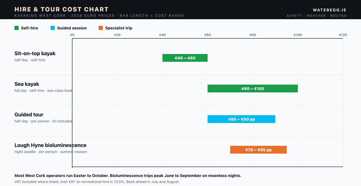
| What you book | Format | Typical 2026 range | Notes |
|---|---|---|---|
| Sit-on-top kayak | Half day, self-hire | €40 – €60 | Most common rental at Schull, Glengarriff, Baltimore |
| Sea kayak | Full day, self-hire | €60 – €100 | Sea-class boat for Bantry, Roaringwater, outer coast |
| Guided tour | Half day, per person | €60 – €90 | Includes boat, PFD, instructor |
| Lough Hyne bioluminescence | Night paddle, per person | €70 – €95 | June – September, moonless nights, guided only |
VAT included where listed; Irish VAT on recreational hire is 13.5%. Tipping is not standard. Most West Cork operators run Easter to October, with bioluminescence trips peaking June to September. Book ahead in July and August.
Clubs and Instructors in West Cork
West Cork Kayak Club is the main community paddling group in the region, running club paddles year-round and welcoming visitors during the open season. Their meet-ups are typically on Bantry Bay or Glengarriff, with occasional trips to Roaringwater and Lough Hyne.
For accredited instruction, the WaterEgo clubs directory lists every Canoeing Ireland-affiliated club and instructor in the country. Canoeing Ireland’s award scheme covers Levels 1 through 5 in sea kayaking; Level 3 is the standard for moderate Irish coastal conditions and is the qualification most West Cork paddlers aim for.
Commercial operators in West Cork also offer guided sessions and skills courses. The standard pattern is half-day to two-day intro courses with kit included.
Safety — The Three Things That Catch People Out
Most West Cork incidents follow one of three patterns.
1. Offshore wind on the open coast
A light north or north-easterly feels calm at the launch. Once you are 500 metres offshore, it has pushed you another 100 metres further. Now the wind that felt fine inshore is genuinely a problem. Never launch into an offshore wind on the outer coast without a clear escape plan.
2. Underestimating Roaringwater Bay’s open crossings
The bay looks sheltered from Schull. The 6 km crossing to Cape Clear looks like a half-hour paddle. It is not. Wind funnels through the gaps between the islands, swell rolls in from the south-west, and the second half of the crossing has no landing option until you reach the island. Treat it as a committed open-water trip, not a casual outing.
3. Cold-water shock outside summer
Irish sea temperature on the West Cork coast ranges from about 9 °C in February to 16 °C in late August. Cold-water shock — the gasp reflex on sudden immersion — can incapacitate even a strong swimmer within a minute below 12 °C. October to May, wear immersion gear. Always.
The Irish Coast Guard runs the 999/112 emergency number on the coast, and the nearest stations cover the West Cork coast: Bantry, Goleen, Castlefreke, Toe Head, and Bere Island.
Common Mistakes
Patterns we see from new West Cork paddlers:
- Picking Mizen for a first outing. Wrong call. Pick Glengarriff Bay or Lough Hyne. Build up.
- Not checking the forecast on the right side of the peninsula. Bantry Bay can be flat while Dunmanus Bay is whipped — they are 5 km apart but the wind direction matters more than the distance.
- Skipping a dry bag. A capsize at the far end of Roaringwater Bay, 6 km from the car park, with no spare layer, is the start of hypothermia.
- Trying to paddle through The Rapids at Lough Hyne. No. Walk around. The current at peak flow has killed swimmers.
- Booking a bioluminescence tour on a full moon. Wasted money. Pick a moonless night, late summer.
- Paddling out from Castletownbere without watching the ferry schedule. The Bere Island ferry has right of way and runs every hour in summer. Cross between sailings.
- Not telling anyone where you are going. Always leave a float plan with a friend onshore: launch point, route, expected return time.
Frequently Asked Questions
Is kayaking West Cork safe for beginners?
Yes, on the right water. Glengarriff Bay, Lough Hyne, and the inner sections of Bantry Bay and Schull harbour are all suitable for a first paddle on a settled day. Avoid Mizen Head, the outer Roaringwater Bay crossings, and any committed crossings (Bere Island, Cape Clear) until you have at least a Canoeing Ireland Level 2 or equivalent club experience.
What is the best time of year for kayaking in West Cork?
June and September are the two sweet spots. June gives long evenings, warming water, and lower crowds than July-August. September gives the best Lough Hyne bioluminescence, still-warm sea temperatures, and quieter beaches. May and October work for experienced paddlers in wetsuits or drysuits.
Can you kayak on Lough Hyne?
Yes. The lake is open to recreational paddlers year-round. Launch from the small slipway on the western shore (signposted from the R596 south of Skibbereen). Do not attempt to paddle through The Rapids — lift out, walk around. Several outfitters run guided bioluminescence kayak trips on summer nights.
Do you need a licence to kayak in West Cork?
No. Recreational kayaking on Irish coastal waters does not require a licence. Hire operators are registered for commercial trade, but private paddlers, clubs, and visitors paddle without permit. Common sense and the Met Éireann forecast are the only mandatory inputs.
Where can you see seals while kayaking in West Cork?
Roaringwater Bay (around the Calf Islands and Heir Island), the rocks off Whiddy in Bantry Bay, and the western end of Garnish Island in Glengarriff are the most reliable spots. Stay at least 30 metres clear of haul-outs, especially during pup season (September-November). Several commercial operators run “kayak with seals” tours in Glengarriff and Roaringwater.
How much does kayak hire cost in West Cork?
Sit-on-top kayaks typically €25-35 for a half day, €40-50 full day. Sea kayaks €30-40 half / €60-90 full. Guided half-day sessions €60-90 per person. Bioluminescence tours on Lough Hyne €70-95 per person. VAT included; tipping is not standard.
What about Atlantic Sea Kayaking — is that a separate thing from kayaking West Cork?
Atlantic Sea Kayaking is the trading name of a commercial tour operator based in Castletownshend. The term also describes the broader activity — paddling on the Atlantic-facing West Cork coast. This article uses the activity sense throughout; the commercial operator is one of several in the region.
Final Word — Where to Start in West Cork
The honest summary of this guide:
- First-time paddler in West Cork: book a guided session at Glengarriff Bay, or hire a sit-on-top from Schull pier for a quiet hour. Skip the outer coast entirely until you have a couple of sessions under your belt.
- Improver with one season of experience: Lough Hyne for the sheltered novelty, then Bantry Bay for the Whiddy crossing, then Roaringwater Bay inshore from Schull. Six paddles in West Cork on settled days is enough to confidently move to intermediate-grade outings.
- Experienced paddler visiting for the first time: head straight for Schull and plan a Roaringwater Bay island-hop. Use Castletownshend as a base for outer-coast paddling once the forecast supports it. Save Bere Island, Cape Clear, and outer Mizen for the right day — and never push the weather window on the Atlantic coast.
- One paddle, never again: a midnight Lough Hyne bioluminescence trip in late August on a moonless night. There is nothing else like it in Ireland.
West Cork is sheltered enough for a learner and serious enough for a guide. That is rare. Pick the right launch, check the forecast, wear the right kit, and the region delivers.
If you want to start exploring routes, browse the WaterEgo routes directory, find a club or instructor near you, or read the Sea Kayaking Ireland pillar for the broader coastal context.
Also Read
- Sea Kayaking Ireland — The Complete Paddler’s Guide — the saltwater pillar covering weather, rescue, gear, and 12 locations across the island.
- Blueways Ireland — Every Paddling Trail Mapped — flat-water alternative for paddlers who want sheltered freshwater before tackling West Cork.
- Bantry Bay route page — the standard West Cork starter route, full launch and crossing detail.
- Glengarriff Bay route page — the most forgiving open-water paddle in Munster.
- Find a Kayaking Club or Certified Instructor — Canoeing Ireland-affiliated clubs across the country.
No comments yet on this route.
Be the first to share your experience — conditions, access, hazards, or anything a future paddler should know.
Login to join the discussion